You are here: Home > Network List > TA - USArray Transportable Network (new EarthScope stations) Stations List
> Station P27A Ficken Ranch, Kirk, CO, USA > Earthquake Result Viewer
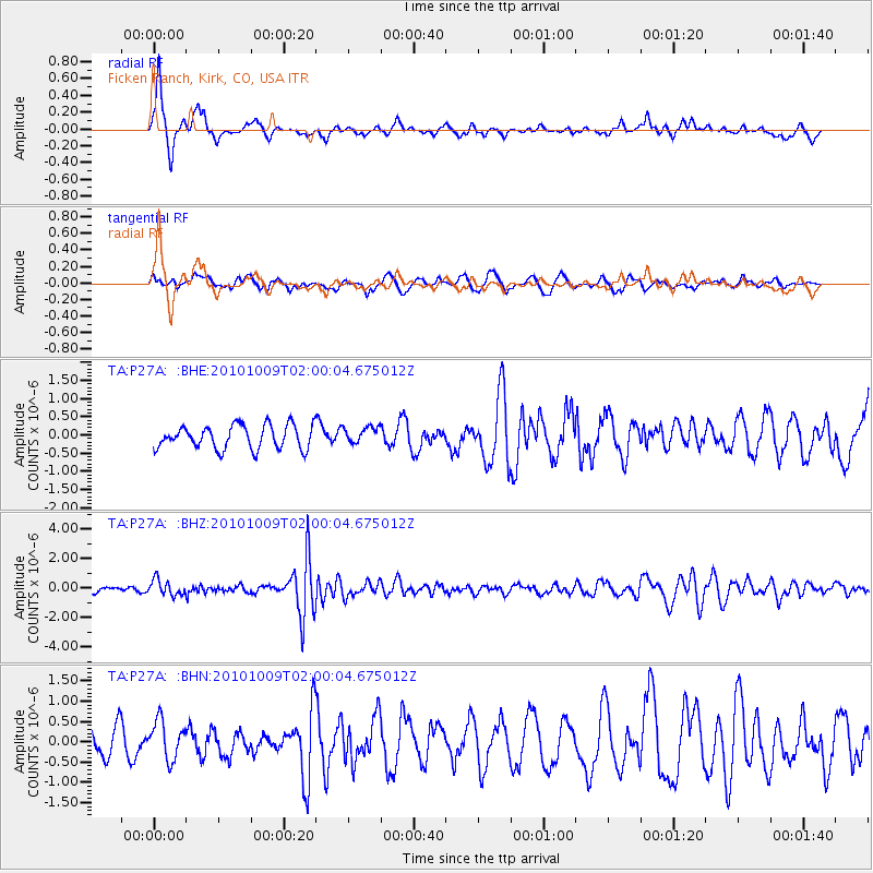
P27A Ficken Ranch, Kirk, CO, USA - Earthquake Result Viewer
*The percent match for this event was below the threshold and hence no stack was calculated.
| Earthquake location: |
Costa Rica |
| Earthquake latitude/longitude: |
10.2/-84.3 |
| Earthquake time(UTC): |
2010/10/09 (282) 01:54:04 GMT |
| Earthquake Depth: |
91 km |
| Earthquake Magnitude: |
5.5 MB, 5.8 MW, 5.8 MW |
| Earthquake Catalog/Contributor: |
WHDF/NEIC |
|
| Network: |
TA USArray Transportable Network (new EarthScope stations) |
| Station: |
P27A Ficken Ranch, Kirk, CO, USA |
| Lat/Lon: |
39.56 N/102.58 W |
| Elevation: |
1286 m |
|
| Distance: |
33.5 deg |
| Az: |
333.898 deg |
| Baz: |
145.931 deg |
| Ray Param: |
$rayparam |
*The percent match for this event was below the threshold and hence was not used in the summary stack. |
|
| Radial Match: |
76.249176 % |
| Radial Bump: |
324 |
| Transverse Match: |
30.218166 % |
| Transverse Bump: |
350 |
| SOD ConfigId: |
339645 |
| Insert Time: |
2011-02-10 08:42:46.474 +0000 |
| GWidth: |
2.5 |
| Max Bumps: |
400 |
| Tol: |
0.001 |
|
Signal To Noise
| Channel | StoN | STA | LTA |
| TA:P27A: :BHZ:20101009T02:00:04.675012Z | 2.8364446 | 5.3334E-7 | 1.8803117E-7 |
| TA:P27A: :BHN:20101009T02:00:04.675012Z | 1.2091688 | 4.6679284E-7 | 3.8604438E-7 |
| TA:P27A: :BHE:20101009T02:00:04.675012Z | 0.71036637 | 2.2851174E-7 | 3.2168154E-7 |
| Arrivals |
| Ps | |
| PpPs | |
| PsPs/PpSs | |


