You are here: Home > Network List > TA - USArray Transportable Network (new EarthScope stations) Stations List
> Station S28A Manter, KS, USA > Earthquake Result Viewer
S28A Manter, KS, USA - Earthquake Result Viewer
*The percent match for this event was below the threshold and hence no stack was calculated.
| Earthquake location: |
Costa Rica |
| Earthquake latitude/longitude: |
10.2/-84.3 |
| Earthquake time(UTC): |
2010/10/09 (282) 01:54:04 GMT |
| Earthquake Depth: |
91 km |
| Earthquake Magnitude: |
5.5 MB, 5.8 MW, 5.8 MW |
| Earthquake Catalog/Contributor: |
WHDF/NEIC |
|
| Network: |
TA USArray Transportable Network (new EarthScope stations) |
| Station: |
S28A Manter, KS, USA |
| Lat/Lon: |
37.59 N/101.90 W |
| Elevation: |
1064 m |
|
| Distance: |
31.5 deg |
| Az: |
332.654 deg |
| Baz: |
145.304 deg |
| Ray Param: |
$rayparam |
*The percent match for this event was below the threshold and hence was not used in the summary stack. |
|
| Radial Match: |
70.68431 % |
| Radial Bump: |
368 |
| Transverse Match: |
70.567444 % |
| Transverse Bump: |
400 |
| SOD ConfigId: |
339645 |
| Insert Time: |
2011-02-10 08:43:11.359 +0000 |
| GWidth: |
2.5 |
| Max Bumps: |
400 |
| Tol: |
0.001 |
|
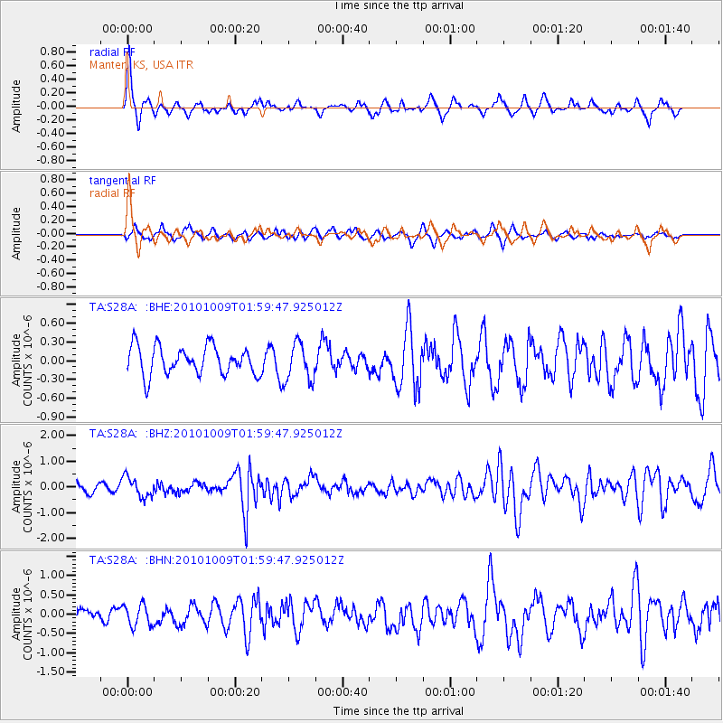
Signal To Noise
| Channel | StoN | STA | LTA |
| TA:S28A: :BHZ:20101009T01:59:47.925012Z | 1.7402043 | 3.9882553E-7 | 2.2918316E-7 |
| TA:S28A: :BHN:20101009T01:59:47.925012Z | 1.1340467 | 2.7734055E-7 | 2.4455832E-7 |
| TA:S28A: :BHE:20101009T01:59:47.925012Z | 1.3327802 | 3.0079826E-7 | 2.2569233E-7 |
| Arrivals |
| Ps | |
| PpPs | |
| PsPs/PpSs | |


