You are here: Home > Network List > UW - Pacific Northwest Regional Seismic Network Stations List
> Station TOUCH McClure Farm, Touchet, WA, USA > Earthquake Result Viewer
TOUCH McClure Farm, Touchet, WA, USA - Earthquake Result Viewer
| Earthquake location: |
Mariana Islands |
| Earthquake latitude/longitude: |
15.8/146.9 |
| Earthquake time(UTC): |
2024/04/02 (093) 09:54:09 GMT |
| Earthquake Depth: |
10 km |
| Earthquake Magnitude: |
6.2 mww |
| Earthquake Catalog/Contributor: |
NEIC PDE/us |
|
| Network: |
UW Pacific Northwest Regional Seismic Network |
| Station: |
TOUCH McClure Farm, Touchet, WA, USA |
| Lat/Lon: |
46.02 N/118.63 W |
| Elevation: |
142 m |
|
| Distance: |
81.9 deg |
| Az: |
44.564 deg |
| Baz: |
284.206 deg |
| Ray Param: |
0.04729522 |
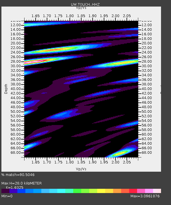
| Estimated Moho Depth: |
28.0 km |
| Estimated Crust Vp/Vs: |
1.63 |
| Assumed Crust Vp: |
6.419 km/s |
| Estimated Crust Vs: |
3.932 km/s |
| Estimated Crust Poisson's Ratio: |
0.20 |
|
| Radial Match: |
90.5046 % |
| Radial Bump: |
400 |
| Transverse Match: |
81.75105 % |
| Transverse Bump: |
400 |
| SOD ConfigId: |
34025071 |
| Insert Time: |
2024-04-16 10:23:33.216 +0000 |
| GWidth: |
2.5 |
| Max Bumps: |
400 |
| Tol: |
0.001 |
|

Signal To Noise
| Channel | StoN | STA | LTA |
| UW:TOUCH: :HHZ:20240402T10:05:56.92002Z | 2.3984523 | 7.984017E-7 | 3.3288205E-7 |
| UW:TOUCH: :HHN:20240402T10:05:56.92002Z | 0.74142605 | 2.4244127E-7 | 3.2699322E-7 |
| UW:TOUCH: :HHE:20240402T10:05:56.92002Z | 0.9758866 | 3.4476477E-7 | 3.5328364E-7 |
| Arrivals |
| Ps | 2.8 SECOND |
| PpPs | 11 SECOND |
| PsPs/PpSs | 14 SECOND |


