You are here: Home > Network List > UW - Pacific Northwest Regional Seismic Network Stations List
> Station WAT2 Waterville, WA, USA > Earthquake Result Viewer
WAT2 Waterville, WA, USA - Earthquake Result Viewer
| Earthquake location: |
Mariana Islands |
| Earthquake latitude/longitude: |
15.8/146.9 |
| Earthquake time(UTC): |
2024/04/02 (093) 09:54:09 GMT |
| Earthquake Depth: |
10 km |
| Earthquake Magnitude: |
6.2 mww |
| Earthquake Catalog/Contributor: |
NEIC PDE/us |
|
| Network: |
UW Pacific Northwest Regional Seismic Network |
| Station: |
WAT2 Waterville, WA, USA |
| Lat/Lon: |
47.62 N/120.11 W |
| Elevation: |
875 m |
|
| Distance: |
80.5 deg |
| Az: |
43.234 deg |
| Baz: |
282.924 deg |
| Ray Param: |
0.0482401 |
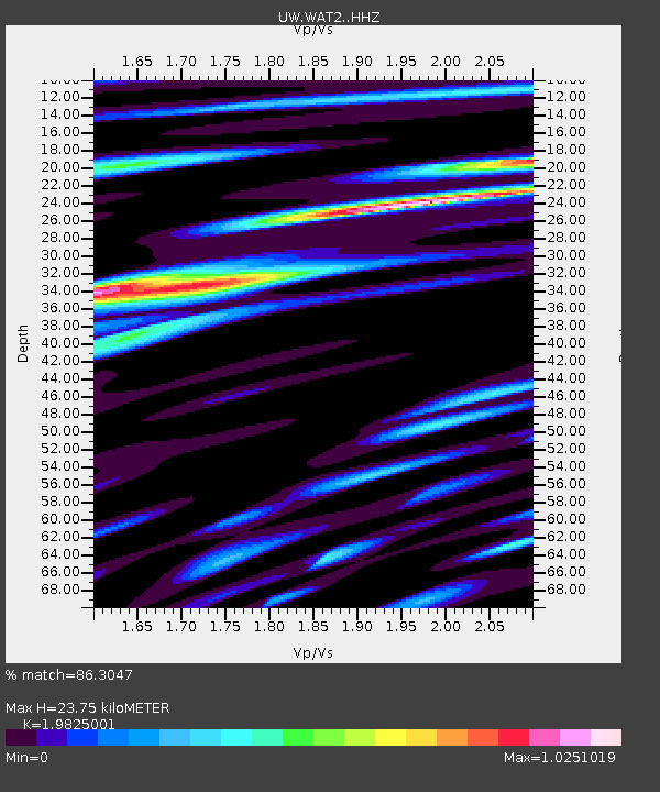
| Estimated Moho Depth: |
23.75 km |
| Estimated Crust Vp/Vs: |
1.98 |
| Assumed Crust Vp: |
6.597 km/s |
| Estimated Crust Vs: |
3.328 km/s |
| Estimated Crust Poisson's Ratio: |
0.33 |
|
| Radial Match: |
86.3047 % |
| Radial Bump: |
400 |
| Transverse Match: |
67.49567 % |
| Transverse Bump: |
400 |
| SOD ConfigId: |
34025071 |
| Insert Time: |
2024-04-16 10:23:42.184 +0000 |
| GWidth: |
2.5 |
| Max Bumps: |
400 |
| Tol: |
0.001 |
|

Signal To Noise
| Channel | StoN | STA | LTA |
| UW:WAT2: :HHZ:20240402T10:05:49.689978Z | 3.9349456 | 6.92641E-7 | 1.7602302E-7 |
| UW:WAT2: :HHN:20240402T10:05:49.689978Z | 1.9818915 | 2.076601E-7 | 1.0477874E-7 |
| UW:WAT2: :HHE:20240402T10:05:49.689978Z | 1.7800987 | 1.8051665E-7 | 1.01408226E-7 |
| Arrivals |
| Ps | 3.6 SECOND |
| PpPs | 10 SECOND |
| PsPs/PpSs | 14 SECOND |


