You are here: Home > Network List > TA - USArray Transportable Network (new EarthScope stations) Stations List
> Station S30A Montezuma, KS, USA > Earthquake Result Viewer
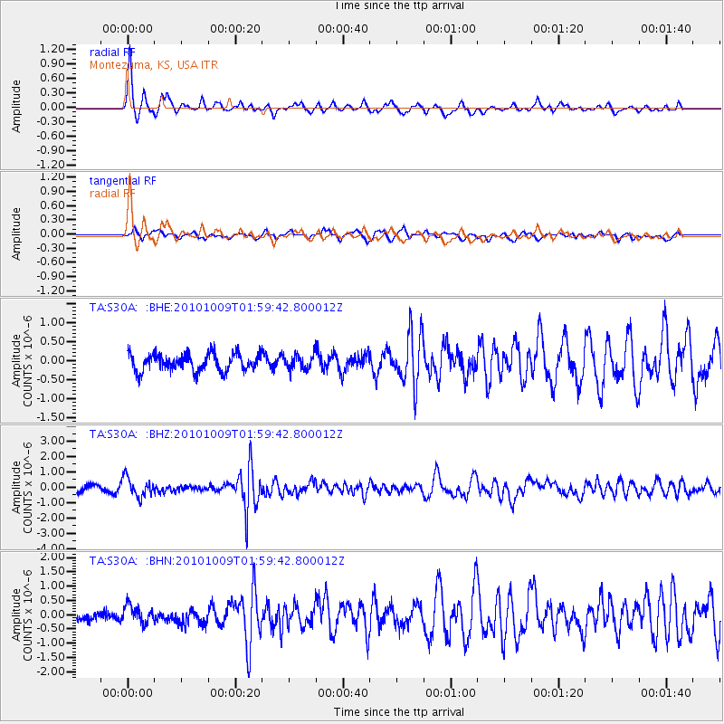
S30A Montezuma, KS, USA - Earthquake Result Viewer
*The percent match for this event was below the threshold and hence no stack was calculated.
| Earthquake location: |
Costa Rica |
| Earthquake latitude/longitude: |
10.2/-84.3 |
| Earthquake time(UTC): |
2010/10/09 (282) 01:54:04 GMT |
| Earthquake Depth: |
91 km |
| Earthquake Magnitude: |
5.5 MB, 5.8 MW, 5.8 MW |
| Earthquake Catalog/Contributor: |
WHDF/NEIC |
|
| Network: |
TA USArray Transportable Network (new EarthScope stations) |
| Station: |
S30A Montezuma, KS, USA |
| Lat/Lon: |
37.64 N/100.46 W |
| Elevation: |
853 m |
|
| Distance: |
30.9 deg |
| Az: |
334.539 deg |
| Baz: |
147.787 deg |
| Ray Param: |
$rayparam |
*The percent match for this event was below the threshold and hence was not used in the summary stack. |
|
| Radial Match: |
77.410355 % |
| Radial Bump: |
305 |
| Transverse Match: |
65.58177 % |
| Transverse Bump: |
400 |
| SOD ConfigId: |
339645 |
| Insert Time: |
2011-02-10 08:43:23.460 +0000 |
| GWidth: |
2.5 |
| Max Bumps: |
400 |
| Tol: |
0.001 |
|
Signal To Noise
| Channel | StoN | STA | LTA |
| TA:S30A: :BHZ:20101009T01:59:42.800012Z | 2.704688 | 6.19012E-7 | 2.2886633E-7 |
| TA:S30A: :BHN:20101009T01:59:42.800012Z | 1.0838497 | 3.1044425E-7 | 2.864274E-7 |
| TA:S30A: :BHE:20101009T01:59:42.800012Z | 0.82998616 | 1.9163379E-7 | 2.3088793E-7 |
| Arrivals |
| Ps | |
| PpPs | |
| PsPs/PpSs | |


