You are here: Home > Network List > WW - Idaho Seismic Network () Stations List
> Station TYLR Tyler Ranch Idaho > Earthquake Result Viewer
TYLR Tyler Ranch Idaho - Earthquake Result Viewer
| Earthquake location: |
Mariana Islands |
| Earthquake latitude/longitude: |
15.8/146.9 |
| Earthquake time(UTC): |
2024/04/02 (093) 09:54:09 GMT |
| Earthquake Depth: |
10 km |
| Earthquake Magnitude: |
6.2 mww |
| Earthquake Catalog/Contributor: |
NEIC PDE/us |
|
| Network: |
WW Idaho Seismic Network () |
| Station: |
TYLR Tyler Ranch Idaho |
| Lat/Lon: |
45.10 N/114.85 W |
| Elevation: |
1203 m |
|
| Distance: |
84.7 deg |
| Az: |
44.74 deg |
| Baz: |
286.917 deg |
| Ray Param: |
0.045327257 |
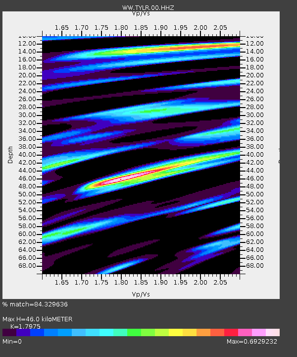
| Estimated Moho Depth: |
46.0 km |
| Estimated Crust Vp/Vs: |
1.80 |
| Assumed Crust Vp: |
6.577 km/s |
| Estimated Crust Vs: |
3.659 km/s |
| Estimated Crust Poisson's Ratio: |
0.28 |
|
| Radial Match: |
84.329636 % |
| Radial Bump: |
400 |
| Transverse Match: |
61.90195 % |
| Transverse Bump: |
400 |
| SOD ConfigId: |
34025071 |
| Insert Time: |
2024-04-16 10:24:16.415 +0000 |
| GWidth: |
2.5 |
| Max Bumps: |
400 |
| Tol: |
0.001 |
|

Signal To Noise
| Channel | StoN | STA | LTA |
| WW:TYLR:00:HHZ:20240402T10:06:11.329993Z | 1.3300058 | 3.24997E-7 | 2.4435758E-7 |
| WW:TYLR:00:HHN:20240402T10:06:11.329993Z | 1.0838922 | 6.181875E-8 | 5.7034043E-8 |
| WW:TYLR:00:HHE:20240402T10:06:11.329993Z | 0.9681679 | 1.13688735E-7 | 1.17426666E-7 |
| Arrivals |
| Ps | 5.7 SECOND |
| PpPs | 19 SECOND |
| PsPs/PpSs | 25 SECOND |


