You are here: Home > Network List > TA - USArray Transportable Network (new EarthScope stations) Stations List
> Station R31A Burdett, KS, USA > Earthquake Result Viewer
R31A Burdett, KS, USA - Earthquake Result Viewer
| Earthquake location: |
Costa Rica |
| Earthquake latitude/longitude: |
10.2/-84.3 |
| Earthquake time(UTC): |
2010/10/09 (282) 01:54:04 GMT |
| Earthquake Depth: |
91 km |
| Earthquake Magnitude: |
5.5 MB, 5.8 MW, 5.8 MW |
| Earthquake Catalog/Contributor: |
WHDF/NEIC |
|
| Network: |
TA USArray Transportable Network (new EarthScope stations) |
| Station: |
R31A Burdett, KS, USA |
| Lat/Lon: |
38.29 N/99.53 W |
| Elevation: |
667 m |
|
| Distance: |
31.1 deg |
| Az: |
336.418 deg |
| Baz: |
149.971 deg |
| Ray Param: |
0.07897622 |
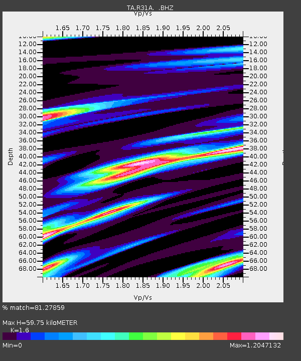
| Estimated Moho Depth: |
59.75 km |
| Estimated Crust Vp/Vs: |
1.60 |
| Assumed Crust Vp: |
6.483 km/s |
| Estimated Crust Vs: |
4.052 km/s |
| Estimated Crust Poisson's Ratio: |
0.18 |
|
| Radial Match: |
81.27859 % |
| Radial Bump: |
320 |
| Transverse Match: |
45.48596 % |
| Transverse Bump: |
375 |
| SOD ConfigId: |
339645 |
| Insert Time: |
2011-02-10 08:44:01.746 +0000 |
| GWidth: |
2.5 |
| Max Bumps: |
400 |
| Tol: |
0.001 |
|
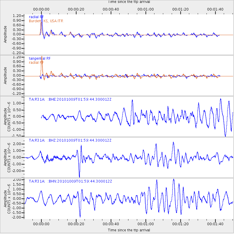
Signal To Noise
| Channel | StoN | STA | LTA |
| TA:R31A: :BHZ:20101009T01:59:44.300012Z | 3.627626 | 4.994636E-7 | 1.3768333E-7 |
| TA:R31A: :BHN:20101009T01:59:44.300012Z | 2.3910303 | 4.8698075E-7 | 2.0366984E-7 |
| TA:R31A: :BHE:20101009T01:59:44.300012Z | 1.4604288 | 2.3682904E-7 | 1.6216404E-7 |
| Arrivals |
| Ps | 6.1 SECOND |
| PpPs | 22 SECOND |
| PsPs/PpSs | 28 SECOND |


