You are here: Home > Network List > TA - USArray Transportable Network (new EarthScope stations) Stations List
> Station O30A M W Ranch, Wilsonville, NE, USA > Earthquake Result Viewer
O30A M W Ranch, Wilsonville, NE, USA - Earthquake Result Viewer
| Earthquake location: |
Costa Rica |
| Earthquake latitude/longitude: |
10.2/-84.3 |
| Earthquake time(UTC): |
2010/10/09 (282) 01:54:04 GMT |
| Earthquake Depth: |
91 km |
| Earthquake Magnitude: |
5.5 MB, 5.8 MW, 5.8 MW |
| Earthquake Catalog/Contributor: |
WHDF/NEIC |
|
| Network: |
TA USArray Transportable Network (new EarthScope stations) |
| Station: |
O30A M W Ranch, Wilsonville, NE, USA |
| Lat/Lon: |
40.18 N/100.06 W |
| Elevation: |
751 m |
|
| Distance: |
33.0 deg |
| Az: |
337.509 deg |
| Baz: |
150.562 deg |
| Ray Param: |
0.07817467 |
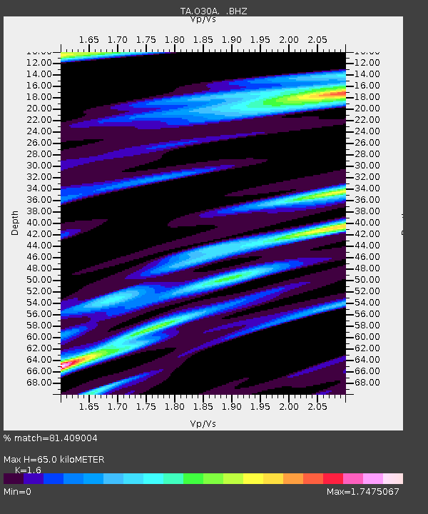
| Estimated Moho Depth: |
65.0 km |
| Estimated Crust Vp/Vs: |
1.60 |
| Assumed Crust Vp: |
6.483 km/s |
| Estimated Crust Vs: |
4.052 km/s |
| Estimated Crust Poisson's Ratio: |
0.18 |
|
| Radial Match: |
81.409004 % |
| Radial Bump: |
285 |
| Transverse Match: |
66.286415 % |
| Transverse Bump: |
400 |
| SOD ConfigId: |
339645 |
| Insert Time: |
2011-02-10 08:44:38.449 +0000 |
| GWidth: |
2.5 |
| Max Bumps: |
400 |
| Tol: |
0.001 |
|

Signal To Noise
| Channel | StoN | STA | LTA |
| TA:O30A: :BHZ:20101009T02:00:00.399988Z | 4.6150126 | 6.163587E-7 | 1.3355516E-7 |
| TA:O30A: :BHN:20101009T02:00:00.399988Z | 2.179032 | 5.1170286E-7 | 2.3483035E-7 |
| TA:O30A: :BHE:20101009T02:00:00.399988Z | 1.3481975 | 3.4946314E-7 | 2.592077E-7 |
| Arrivals |
| Ps | 6.6 SECOND |
| PpPs | 24 SECOND |
| PsPs/PpSs | 30 SECOND |


