You are here: Home > Network List > TA - USArray Transportable Network (new EarthScope stations) Stations List
> Station H25A Fruitdale, SD, USA > Earthquake Result Viewer
H25A Fruitdale, SD, USA - Earthquake Result Viewer
| Earthquake location: |
Costa Rica |
| Earthquake latitude/longitude: |
10.2/-84.3 |
| Earthquake time(UTC): |
2010/10/09 (282) 01:54:04 GMT |
| Earthquake Depth: |
91 km |
| Earthquake Magnitude: |
5.5 MB, 5.8 MW, 5.8 MW |
| Earthquake Catalog/Contributor: |
WHDF/NEIC |
|
| Network: |
TA USArray Transportable Network (new EarthScope stations) |
| Station: |
H25A Fruitdale, SD, USA |
| Lat/Lon: |
44.62 N/103.60 W |
| Elevation: |
942 m |
|
| Distance: |
38.1 deg |
| Az: |
337.515 deg |
| Baz: |
148.185 deg |
| Ray Param: |
0.07544792 |
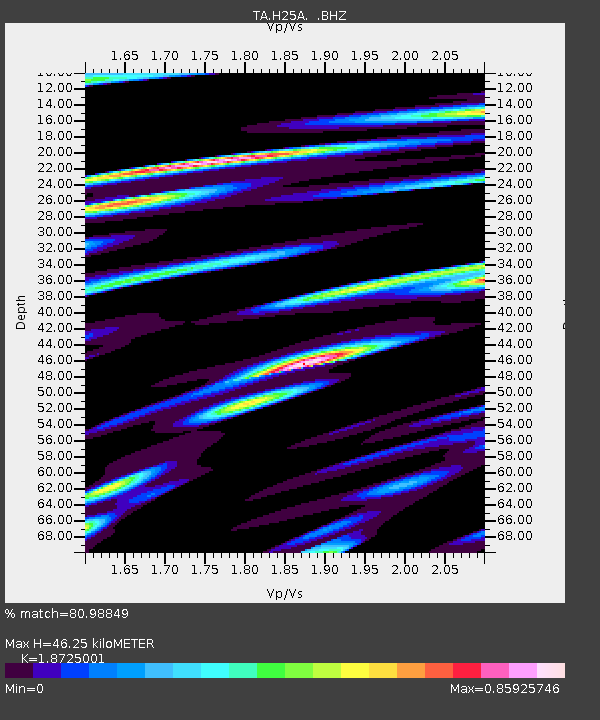
| Estimated Moho Depth: |
46.25 km |
| Estimated Crust Vp/Vs: |
1.87 |
| Assumed Crust Vp: |
6.242 km/s |
| Estimated Crust Vs: |
3.334 km/s |
| Estimated Crust Poisson's Ratio: |
0.30 |
|
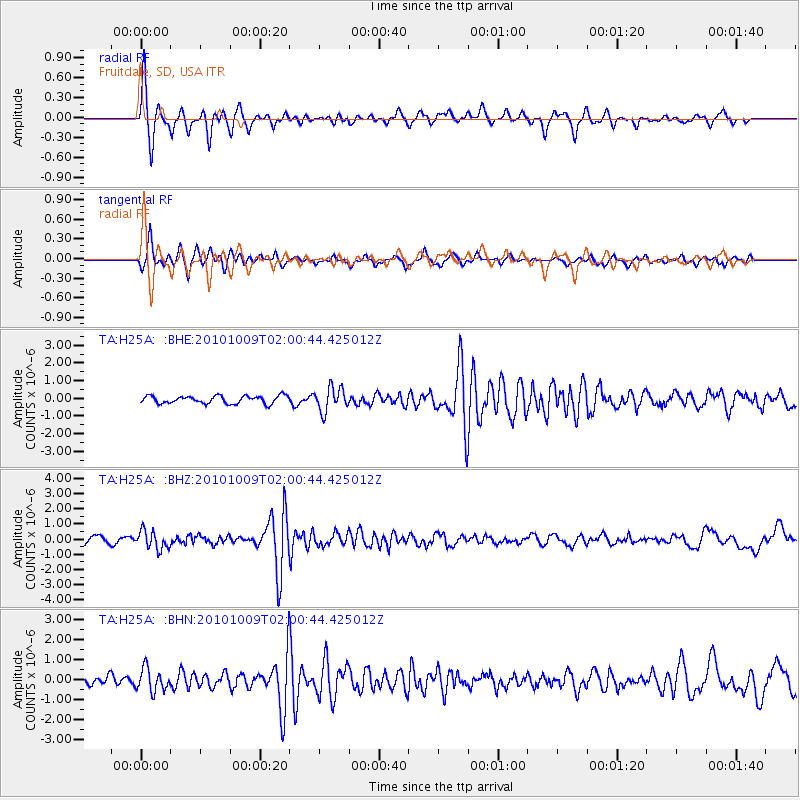
| Radial Match: |
80.98849 % |
| Radial Bump: |
291 |
| Transverse Match: |
72.9776 % |
| Transverse Bump: |
326 |
| SOD ConfigId: |
339645 |
| Insert Time: |
2011-02-10 08:45:23.777 +0000 |
| GWidth: |
2.5 |
| Max Bumps: |
400 |
| Tol: |
0.001 |
|
Signal To Noise
| Channel | StoN | STA | LTA |
| TA:H25A: :BHZ:20101009T02:00:44.425012Z | 2.49463 | 6.0829655E-7 | 2.438424E-7 |
| TA:H25A: :BHN:20101009T02:00:44.425012Z | 2.0931568 | 5.6478143E-7 | 2.698228E-7 |
| TA:H25A: :BHE:20101009T02:00:44.425012Z | 3.0898428 | 6.681815E-7 | 2.1625097E-7 |
| Arrivals |
| Ps | 6.9 SECOND |
| PpPs | 20 SECOND |
| PsPs/PpSs | 27 SECOND |


