You are here: Home > Network List > TA - USArray Transportable Network (new EarthScope stations) Stations List
> Station F27A Lemmon, SD, USA > Earthquake Result Viewer
F27A Lemmon, SD, USA - Earthquake Result Viewer
| Earthquake location: |
Costa Rica |
| Earthquake latitude/longitude: |
10.2/-84.3 |
| Earthquake time(UTC): |
2010/10/09 (282) 01:54:04 GMT |
| Earthquake Depth: |
91 km |
| Earthquake Magnitude: |
5.5 MB, 5.8 MW, 5.8 MW |
| Earthquake Catalog/Contributor: |
WHDF/NEIC |
|
| Network: |
TA USArray Transportable Network (new EarthScope stations) |
| Station: |
F27A Lemmon, SD, USA |
| Lat/Lon: |
45.87 N/102.02 W |
| Elevation: |
757 m |
|
| Distance: |
38.6 deg |
| Az: |
340.081 deg |
| Baz: |
151.314 deg |
| Ray Param: |
0.075149715 |
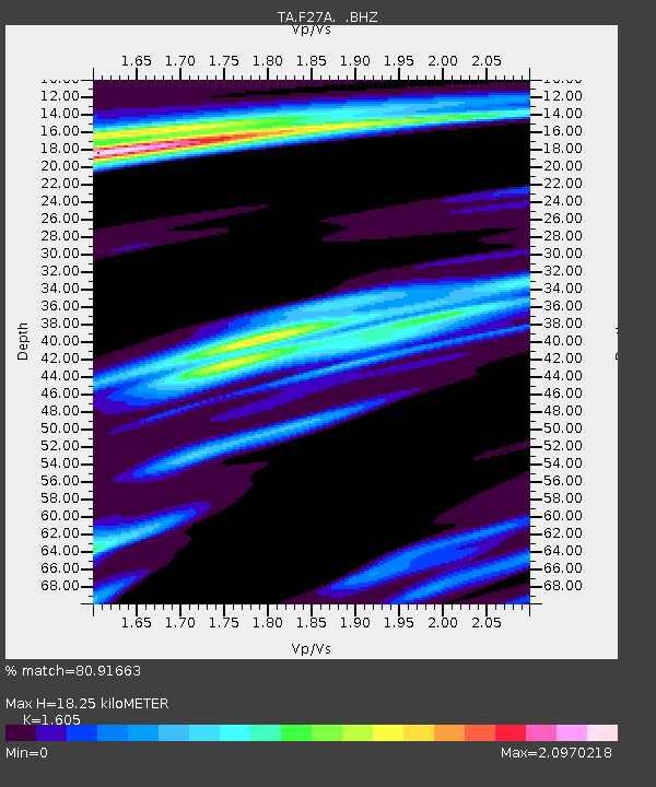
| Estimated Moho Depth: |
18.25 km |
| Estimated Crust Vp/Vs: |
1.61 |
| Assumed Crust Vp: |
6.242 km/s |
| Estimated Crust Vs: |
3.889 km/s |
| Estimated Crust Poisson's Ratio: |
0.18 |
|
| Radial Match: |
80.91663 % |
| Radial Bump: |
270 |
| Transverse Match: |
66.109856 % |
| Transverse Bump: |
323 |
| SOD ConfigId: |
339645 |
| Insert Time: |
2011-02-10 08:45:56.346 +0000 |
| GWidth: |
2.5 |
| Max Bumps: |
400 |
| Tol: |
0.001 |
|
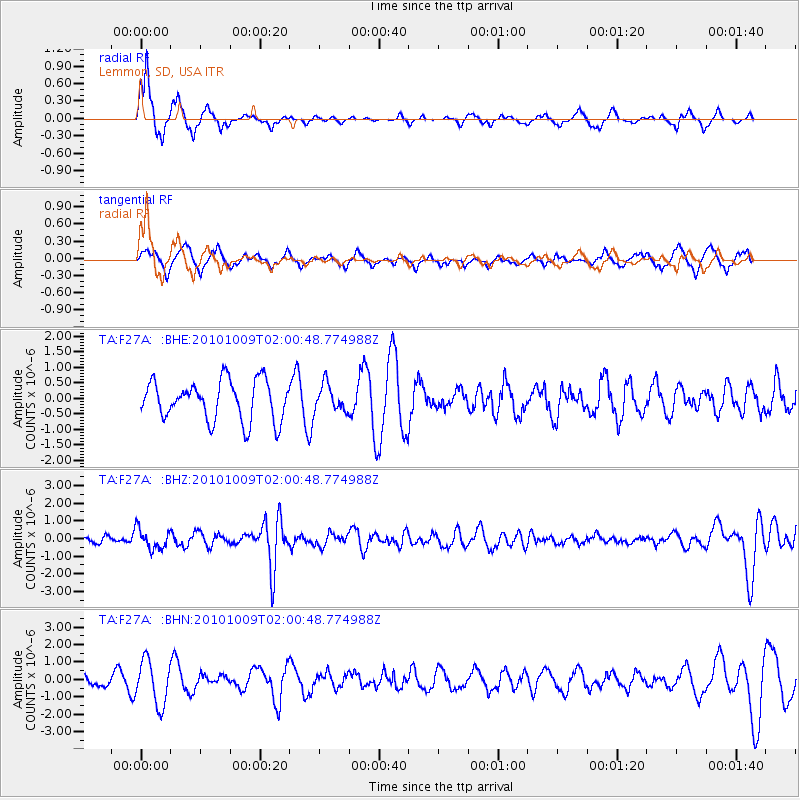
Signal To Noise
| Channel | StoN | STA | LTA |
| TA:F27A: :BHZ:20101009T02:00:48.774988Z | 2.0334132 | 5.751264E-7 | 2.8283796E-7 |
| TA:F27A: :BHN:20101009T02:00:48.774988Z | 2.489436 | 1.2749933E-6 | 5.1216153E-7 |
| TA:F27A: :BHE:20101009T02:00:48.774988Z | 0.66416585 | 4.237191E-7 | 6.3797177E-7 |
| Arrivals |
| Ps | 1.9 SECOND |
| PpPs | 7.1 SECOND |
| PsPs/PpSs | 9.0 SECOND |


