You are here: Home > Network List > AK - Alaska Regional Network Stations List
> Station F20K Avaraart Lake, AK, USA > Earthquake Result Viewer
F20K Avaraart Lake, AK, USA - Earthquake Result Viewer
| Earthquake location: |
Taiwan |
| Earthquake latitude/longitude: |
23.8/121.6 |
| Earthquake time(UTC): |
2024/04/02 (093) 23:58:11 GMT |
| Earthquake Depth: |
35 km |
| Earthquake Magnitude: |
7.4 mww |
| Earthquake Catalog/Contributor: |
NEIC PDE/us |
|
| Network: |
AK Alaska Regional Network |
| Station: |
F20K Avaraart Lake, AK, USA |
| Lat/Lon: |
67.05 N/155.73 W |
| Elevation: |
136 m |
|
| Distance: |
65.5 deg |
| Az: |
25.313 deg |
| Baz: |
273.191 deg |
| Ray Param: |
0.058181673 |
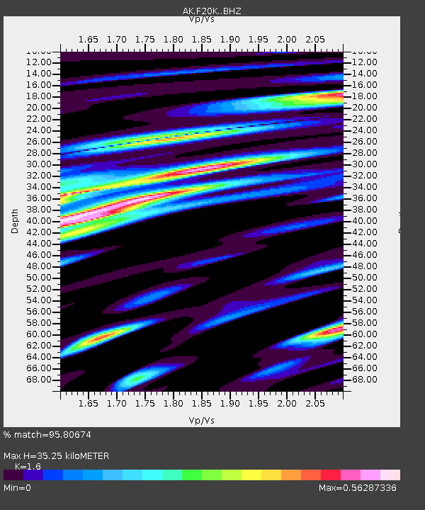
| Estimated Moho Depth: |
35.25 km |
| Estimated Crust Vp/Vs: |
1.60 |
| Assumed Crust Vp: |
6.522 km/s |
| Estimated Crust Vs: |
4.076 km/s |
| Estimated Crust Poisson's Ratio: |
0.18 |
|
| Radial Match: |
95.80674 % |
| Radial Bump: |
373 |
| Transverse Match: |
82.913925 % |
| Transverse Bump: |
400 |
| SOD ConfigId: |
34025071 |
| Insert Time: |
2024-04-17 00:04:02.906 +0000 |
| GWidth: |
2.5 |
| Max Bumps: |
400 |
| Tol: |
0.001 |
|

Signal To Noise
| Channel | StoN | STA | LTA |
| AK:F20K: :BHZ:20240403T00:08:20.040012Z | 29.3412 | 3.2484472E-6 | 1.10712826E-7 |
| AK:F20K: :BHN:20240403T00:08:20.040012Z | 1.2729638 | 1.524071E-7 | 1.1972618E-7 |
| AK:F20K: :BHE:20240403T00:08:20.040012Z | 14.237974 | 1.5517303E-6 | 1.0898533E-7 |
| Arrivals |
| Ps | 3.4 SECOND |
| PpPs | 13 SECOND |
| PsPs/PpSs | 17 SECOND |


