You are here: Home > Network List > AK - Alaska Regional Network Stations List
> Station M16K Timber Creek, AK, USA > Earthquake Result Viewer
M16K Timber Creek, AK, USA - Earthquake Result Viewer
| Earthquake location: |
Taiwan |
| Earthquake latitude/longitude: |
23.8/121.6 |
| Earthquake time(UTC): |
2024/04/02 (093) 23:58:11 GMT |
| Earthquake Depth: |
35 km |
| Earthquake Magnitude: |
7.4 mww |
| Earthquake Catalog/Contributor: |
NEIC PDE/us |
|
| Network: |
AK Alaska Regional Network |
| Station: |
M16K Timber Creek, AK, USA |
| Lat/Lon: |
61.02 N/158.96 W |
| Elevation: |
394 m |
|
| Distance: |
64.4 deg |
| Az: |
32.067 deg |
| Baz: |
273.146 deg |
| Ray Param: |
0.058896743 |
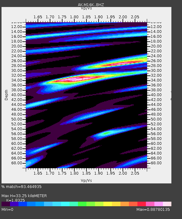
| Estimated Moho Depth: |
33.25 km |
| Estimated Crust Vp/Vs: |
1.83 |
| Assumed Crust Vp: |
6.276 km/s |
| Estimated Crust Vs: |
3.425 km/s |
| Estimated Crust Poisson's Ratio: |
0.29 |
|
| Radial Match: |
93.464935 % |
| Radial Bump: |
400 |
| Transverse Match: |
83.465225 % |
| Transverse Bump: |
400 |
| SOD ConfigId: |
34025071 |
| Insert Time: |
2024-04-17 00:05:15.247 +0000 |
| GWidth: |
2.5 |
| Max Bumps: |
400 |
| Tol: |
0.001 |
|

Signal To Noise
| Channel | StoN | STA | LTA |
| AK:M16K: :BHZ:20240403T00:08:12.980014Z | 10.920602 | 2.3306545E-6 | 2.1341815E-7 |
| AK:M16K: :BHN:20240403T00:08:12.980014Z | 0.95770025 | 1.9584839E-7 | 2.0449863E-7 |
| AK:M16K: :BHE:20240403T00:08:12.980014Z | 3.7898686 | 7.332659E-7 | 1.9348056E-7 |
| Arrivals |
| Ps | 4.6 SECOND |
| PpPs | 14 SECOND |
| PsPs/PpSs | 19 SECOND |


