You are here: Home > Network List > AK - Alaska Regional Network Stations List
> Station MDM Murphy Dome > Earthquake Result Viewer
MDM Murphy Dome - Earthquake Result Viewer

| Earthquake location: |
Taiwan |
| Earthquake latitude/longitude: |
23.8/121.6 |
| Earthquake time(UTC): |
2024/04/02 (093) 23:58:11 GMT |
| Earthquake Depth: |
35 km |
| Earthquake Magnitude: |
7.4 mww |
| Earthquake Catalog/Contributor: |
NEIC PDE/us |
|
| Network: |
AK Alaska Regional Network |
| Station: |
MDM Murphy Dome |
| Lat/Lon: |
64.96 N/148.23 W |
| Elevation: |
634 m |
|
| Distance: |
68.8 deg |
| Az: |
27.166 deg |
| Baz: |
280.754 deg |
| Ray Param: |
0.05603277 |
| Estimated Moho Depth: |
31.75 km |
| Estimated Crust Vp/Vs: |
1.65 |
| Assumed Crust Vp: |
6.566 km/s |
| Estimated Crust Vs: |
3.98 km/s |
| Estimated Crust Poisson's Ratio: |
0.21 |
|
| Radial Match: |
97.84788 % |
| Radial Bump: |
400 |
| Transverse Match: |
90.66104 % |
| Transverse Bump: |
400 |
| SOD ConfigId: |
34025071 |
| Insert Time: |
2024-04-17 00:05:25.888 +0000 |
| GWidth: |
2.5 |
| Max Bumps: |
400 |
| Tol: |
0.001 |
|
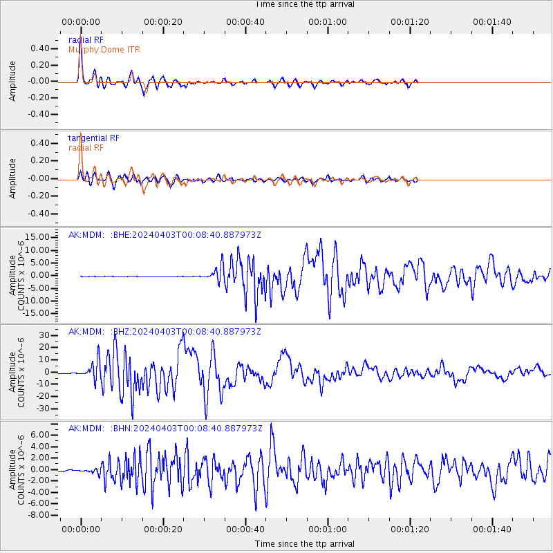
Signal To Noise
| Channel | StoN | STA | LTA |
| AK:MDM: :BHZ:20240403T00:08:40.887973Z | 48.9049 | 7.595046E-6 | 1.5530236E-7 |
| AK:MDM: :BHN:20240403T00:08:40.887973Z | 2.6644406 | 3.6462265E-7 | 1.3684773E-7 |
| AK:MDM: :BHE:20240403T00:08:40.887973Z | 27.077312 | 2.8924728E-6 | 1.06822746E-7 |
| Arrivals |
| Ps | 3.3 SECOND |
| PpPs | 12 SECOND |
| PsPs/PpSs | 16 SECOND |


