You are here: Home > Network List > TA - USArray Transportable Network (new EarthScope stations) Stations List
> Station O34A Beatrice, NE, USA > Earthquake Result Viewer
O34A Beatrice, NE, USA - Earthquake Result Viewer
| Earthquake location: |
Costa Rica |
| Earthquake latitude/longitude: |
10.2/-84.3 |
| Earthquake time(UTC): |
2010/10/09 (282) 01:54:04 GMT |
| Earthquake Depth: |
91 km |
| Earthquake Magnitude: |
5.5 MB, 5.8 MW, 5.8 MW |
| Earthquake Catalog/Contributor: |
WHDF/NEIC |
|
| Network: |
TA USArray Transportable Network (new EarthScope stations) |
| Station: |
O34A Beatrice, NE, USA |
| Lat/Lon: |
40.18 N/96.69 W |
| Elevation: |
409 m |
|
| Distance: |
31.8 deg |
| Az: |
341.816 deg |
| Baz: |
156.361 deg |
| Ray Param: |
0.078682095 |
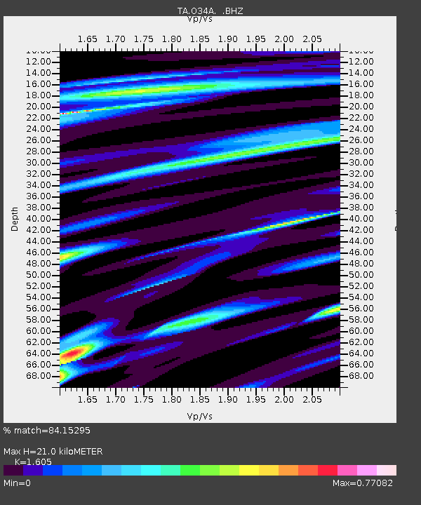
| Estimated Moho Depth: |
21.0 km |
| Estimated Crust Vp/Vs: |
1.61 |
| Assumed Crust Vp: |
6.498 km/s |
| Estimated Crust Vs: |
4.048 km/s |
| Estimated Crust Poisson's Ratio: |
0.18 |
|
| Radial Match: |
84.15295 % |
| Radial Bump: |
372 |
| Transverse Match: |
62.08288 % |
| Transverse Bump: |
400 |
| SOD ConfigId: |
339645 |
| Insert Time: |
2011-02-10 08:50:48.283 +0000 |
| GWidth: |
2.5 |
| Max Bumps: |
400 |
| Tol: |
0.001 |
|

Signal To Noise
| Channel | StoN | STA | LTA |
| TA:O34A: :BHZ:20101009T01:59:50.399988Z | 4.6094327 | 9.090656E-7 | 1.9721853E-7 |
| TA:O34A: :BHN:20101009T01:59:50.399988Z | 2.222333 | 3.9840097E-7 | 1.792715E-7 |
| TA:O34A: :BHE:20101009T01:59:50.399988Z | 1.2062279 | 2.7227026E-7 | 2.2572041E-7 |
| Arrivals |
| Ps | 2.1 SECOND |
| PpPs | 7.7 SECOND |
| PsPs/PpSs | 9.8 SECOND |


