You are here: Home > Network List > TA - USArray Transportable Network (new EarthScope stations) Stations List
> Station M35A Neola, IA, USA > Earthquake Result Viewer
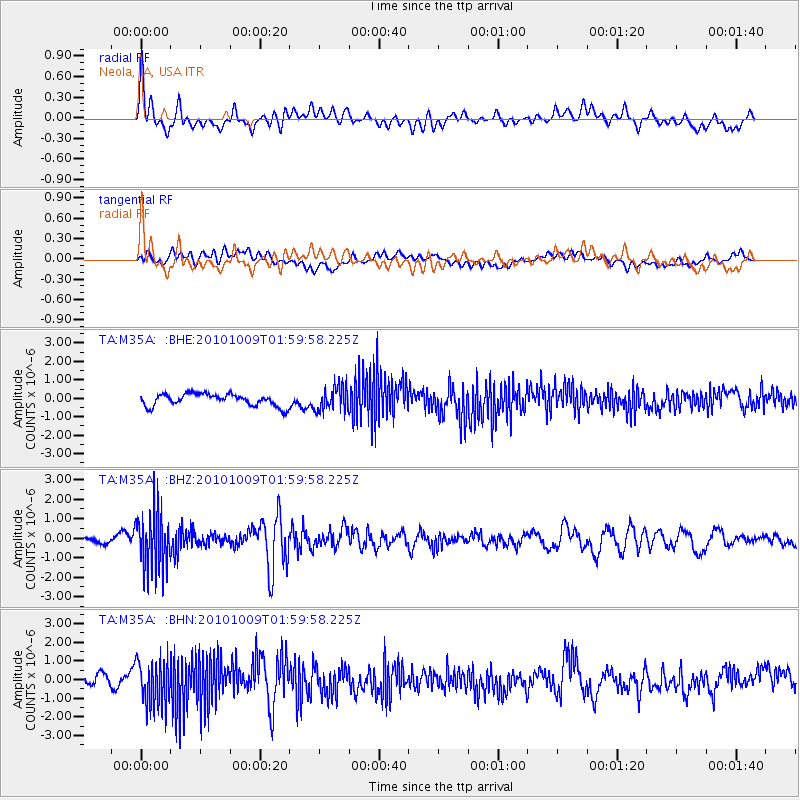
M35A Neola, IA, USA - Earthquake Result Viewer
*The percent match for this event was below the threshold and hence no stack was calculated.
| Earthquake location: |
Costa Rica |
| Earthquake latitude/longitude: |
10.2/-84.3 |
| Earthquake time(UTC): |
2010/10/09 (282) 01:54:04 GMT |
| Earthquake Depth: |
91 km |
| Earthquake Magnitude: |
5.5 MB, 5.8 MW, 5.8 MW |
| Earthquake Catalog/Contributor: |
WHDF/NEIC |
|
| Network: |
TA USArray Transportable Network (new EarthScope stations) |
| Station: |
M35A Neola, IA, USA |
| Lat/Lon: |
41.47 N/95.69 W |
| Elevation: |
363 m |
|
| Distance: |
32.7 deg |
| Az: |
344.044 deg |
| Baz: |
158.896 deg |
| Ray Param: |
$rayparam |
*The percent match for this event was below the threshold and hence was not used in the summary stack. |
|
| Radial Match: |
53.81464 % |
| Radial Bump: |
400 |
| Transverse Match: |
39.615925 % |
| Transverse Bump: |
400 |
| SOD ConfigId: |
339645 |
| Insert Time: |
2011-02-10 08:51:01.277 +0000 |
| GWidth: |
2.5 |
| Max Bumps: |
400 |
| Tol: |
0.001 |
|
Signal To Noise
| Channel | StoN | STA | LTA |
| TA:M35A: :BHZ:20101009T01:59:58.225Z | 8.605689 | 1.4812106E-6 | 1.7211993E-7 |
| TA:M35A: :BHN:20101009T01:59:58.225Z | 4.3510385 | 1.246707E-6 | 2.865309E-7 |
| TA:M35A: :BHE:20101009T01:59:58.225Z | 1.9557161 | 6.495052E-7 | 3.3210605E-7 |
| Arrivals |
| Ps | |
| PpPs | |
| PsPs/PpSs | |


