You are here: Home > Network List > XG92 - Rocky Mountain Front Stations List
> Station DOT Dotsero, CO > Earthquake Result Viewer
DOT Dotsero, CO - Earthquake Result Viewer
| Earthquake location: |
Svalbard Region |
| Earthquake latitude/longitude: |
76.2/7.2 |
| Earthquake time(UTC): |
1992/09/09 (253) 13:08:54 GMT |
| Earthquake Depth: |
24 km |
| Earthquake Magnitude: |
5.7 MB, 5.6 MS |
| Earthquake Catalog/Contributor: |
WHDF/NEIC |
|
| Network: |
XG Rocky Mountain Front |
| Station: |
DOT Dotsero, CO |
| Lat/Lon: |
39.78 N/106.99 W |
| Elevation: |
1982 m |
|
| Distance: |
57.1 deg |
| Az: |
303.205 deg |
| Baz: |
15.102 deg |
| Ray Param: |
0.063653976 |
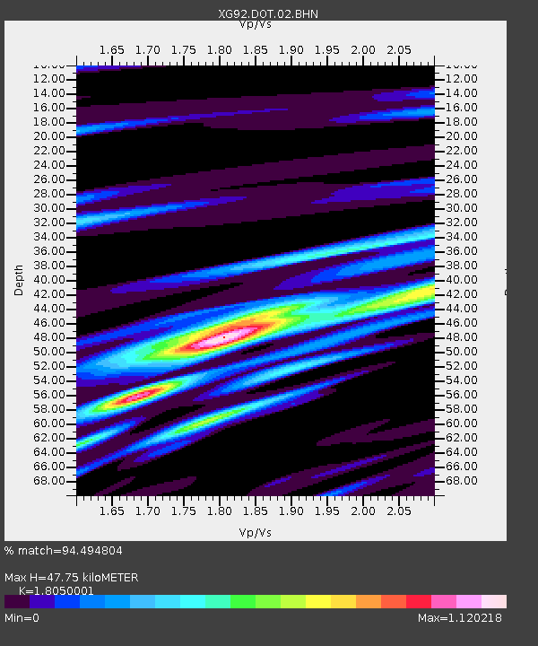
| Estimated Moho Depth: |
47.75 km |
| Estimated Crust Vp/Vs: |
1.81 |
| Assumed Crust Vp: |
6.306 km/s |
| Estimated Crust Vs: |
3.494 km/s |
| Estimated Crust Poisson's Ratio: |
0.28 |
|
| Radial Match: |
94.494804 % |
| Radial Bump: |
287 |
| Transverse Match: |
84.67606 % |
| Transverse Bump: |
400 |
| SOD ConfigId: |
3286 |
| Insert Time: |
2010-02-25 20:08:26.334 +0000 |
| GWidth: |
2.5 |
| Max Bumps: |
400 |
| Tol: |
0.001 |
|
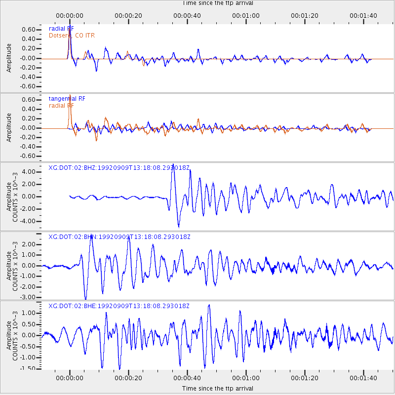
Signal To Noise
| Channel | StoN | STA | LTA |
| XG:DOT:02:BHN:19920909T13:18:08.293018Z | 5.2910047 | 4.6873672E-4 | 8.859125E-5 |
| XG:DOT:02:BHE:19920909T13:18:08.293018Z | 1.9890757 | 2.878526E-4 | 1.4471676E-4 |
| XG:DOT:02:BHZ:19920909T13:18:08.293018Z | 6.0587597 | 0.001062605 | 1.7538326E-4 |
| Arrivals |
| Ps | 6.4 SECOND |
| PpPs | 20 SECOND |
| PsPs/PpSs | 27 SECOND |


