You are here: Home > Network List > AU - Australian Seismological Centre Stations List
> Station KIM05 GSWA station > Earthquake Result Viewer
KIM05 GSWA station - Earthquake Result Viewer
| Earthquake location: |
Taiwan |
| Earthquake latitude/longitude: |
23.8/121.6 |
| Earthquake time(UTC): |
2024/04/02 (093) 23:58:11 GMT |
| Earthquake Depth: |
35 km |
| Earthquake Magnitude: |
7.4 mww |
| Earthquake Catalog/Contributor: |
NEIC PDE/us |
|
| Network: |
AU Australian Seismological Centre |
| Station: |
KIM05 GSWA station |
| Lat/Lon: |
17.99 S/124.19 E |
| Elevation: |
70 m |
|
| Distance: |
41.6 deg |
| Az: |
176.235 deg |
| Baz: |
356.377 deg |
| Ray Param: |
0.07359646 |
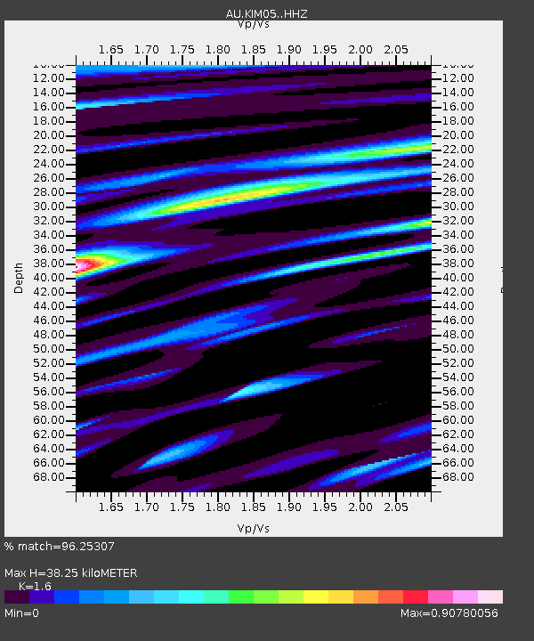
| Estimated Moho Depth: |
38.25 km |
| Estimated Crust Vp/Vs: |
1.60 |
| Assumed Crust Vp: |
6.496 km/s |
| Estimated Crust Vs: |
4.06 km/s |
| Estimated Crust Poisson's Ratio: |
0.18 |
|
| Radial Match: |
96.25307 % |
| Radial Bump: |
400 |
| Transverse Match: |
67.61349 % |
| Transverse Bump: |
400 |
| SOD ConfigId: |
34025071 |
| Insert Time: |
2024-04-17 00:07:25.405 +0000 |
| GWidth: |
2.5 |
| Max Bumps: |
400 |
| Tol: |
0.001 |
|

Signal To Noise
| Channel | StoN | STA | LTA |
| AU:KIM05: :HHZ:20240403T00:05:25.660007Z | 3.9722126 | 1.5936226E-6 | 4.011927E-7 |
| AU:KIM05: :HHN:20240403T00:05:25.660007Z | 2.7239184 | 1.8353109E-6 | 6.7377596E-7 |
| AU:KIM05: :HHE:20240403T00:05:25.660007Z | 3.9516168 | 6.655822E-6 | 1.6843287E-6 |
| Arrivals |
| Ps | 3.8 SECOND |
| PpPs | 14 SECOND |
| PsPs/PpSs | 18 SECOND |


