You are here: Home > Network List > AU - Australian Seismological Centre Stations List
> Station KLBR Kellerberrin, Western Australia > Earthquake Result Viewer
KLBR Kellerberrin, Western Australia - Earthquake Result Viewer
| Earthquake location: |
Taiwan |
| Earthquake latitude/longitude: |
23.8/121.6 |
| Earthquake time(UTC): |
2024/04/02 (093) 23:58:11 GMT |
| Earthquake Depth: |
35 km |
| Earthquake Magnitude: |
7.4 mww |
| Earthquake Catalog/Contributor: |
NEIC PDE/us |
|
| Network: |
AU Australian Seismological Centre |
| Station: |
KLBR Kellerberrin, Western Australia |
| Lat/Lon: |
31.59 S/117.75 E |
| Elevation: |
320 m |
|
| Distance: |
55.2 deg |
| Az: |
183.956 deg |
| Baz: |
4.246 deg |
| Ray Param: |
0.06487268 |
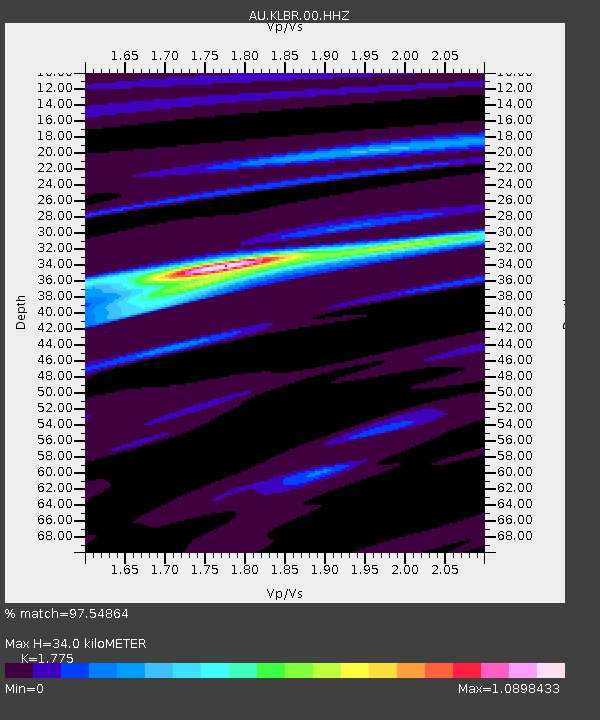
| Estimated Moho Depth: |
34.0 km |
| Estimated Crust Vp/Vs: |
1.77 |
| Assumed Crust Vp: |
6.419 km/s |
| Estimated Crust Vs: |
3.616 km/s |
| Estimated Crust Poisson's Ratio: |
0.27 |
|
| Radial Match: |
97.54864 % |
| Radial Bump: |
270 |
| Transverse Match: |
83.73713 % |
| Transverse Bump: |
400 |
| SOD ConfigId: |
34025071 |
| Insert Time: |
2024-04-17 00:07:32.263 +0000 |
| GWidth: |
2.5 |
| Max Bumps: |
400 |
| Tol: |
0.001 |
|

Signal To Noise
| Channel | StoN | STA | LTA |
| AU:KLBR:00:HHZ:20240403T00:07:10.045017Z | 9.330054 | 2.7535054E-6 | 2.9512213E-7 |
| AU:KLBR:00:HHN:20240403T00:07:10.045017Z | 5.2786016 | 1.4569059E-6 | 2.7600225E-7 |
| AU:KLBR:00:HHE:20240403T00:07:10.045017Z | 0.92835534 | 2.7090226E-7 | 2.918088E-7 |
| Arrivals |
| Ps | 4.3 SECOND |
| PpPs | 14 SECOND |
| PsPs/PpSs | 18 SECOND |


