You are here: Home > Network List > AV - Alaska Volcano Observatory Stations List
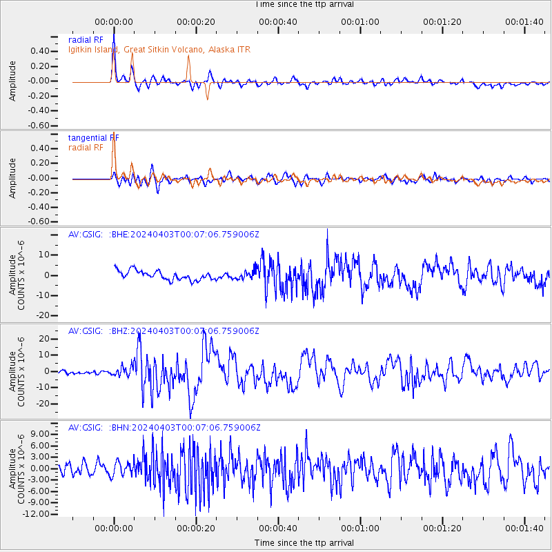
> Station GSIG Igitkin Island, Great Sitkin Volcano, Alaska > Earthquake Result Viewer
GSIG Igitkin Island, Great Sitkin Volcano, Alaska - Earthquake Result Viewer
| Earthquake location: |
Taiwan |
| Earthquake latitude/longitude: |
23.8/121.6 |
| Earthquake time(UTC): |
2024/04/02 (093) 23:58:11 GMT |
| Earthquake Depth: |
35 km |
| Earthquake Magnitude: |
7.4 mww |
| Earthquake Catalog/Contributor: |
NEIC PDE/us |
|
| Network: |
AV Alaska Volcano Observatory |
| Station: |
GSIG Igitkin Island, Great Sitkin Volcano, Alaska |
| Lat/Lon: |
51.99 N/175.93 W |
| Elevation: |
407 m |
|
| Distance: |
54.8 deg |
| Az: |
42.199 deg |
| Baz: |
264.108 deg |
| Ray Param: |
0.06518259 |
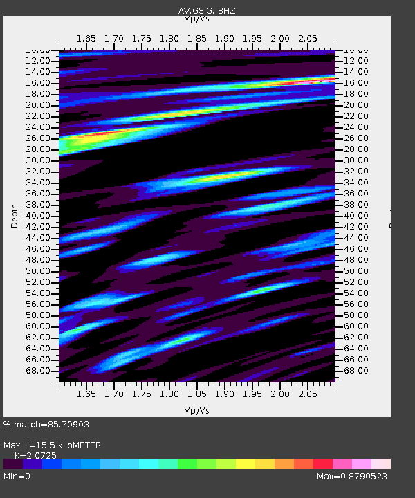
| Estimated Moho Depth: |
15.5 km |
| Estimated Crust Vp/Vs: |
2.07 |
| Assumed Crust Vp: |
3.943 km/s |
| Estimated Crust Vs: |
1.903 km/s |
| Estimated Crust Poisson's Ratio: |
0.35 |
|
| Radial Match: |
85.70903 % |
| Radial Bump: |
400 |
| Transverse Match: |
68.88904 % |
| Transverse Bump: |
400 |
| SOD ConfigId: |
34025071 |
| Insert Time: |
2024-04-17 00:09:04.789 +0000 |
| GWidth: |
2.5 |
| Max Bumps: |
400 |
| Tol: |
0.001 |
|
Signal To Noise
| Channel | StoN | STA | LTA |
| AV:GSIG: :BHZ:20240403T00:07:06.759006Z | 2.4773345 | 3.072319E-6 | 1.2401713E-6 |
| AV:GSIG: :BHN:20240403T00:07:06.759006Z | 1.0005803 | 1.8587657E-6 | 1.8576876E-6 |
| AV:GSIG: :BHE:20240403T00:07:06.759006Z | 0.9850453 | 2.2322304E-6 | 2.2661195E-6 |
| Arrivals |
| Ps | 4.3 SECOND |
| PpPs | 12 SECOND |
| PsPs/PpSs | 16 SECOND |


