You are here: Home > Network List > AV - Alaska Volcano Observatory Stations List
> Station ILNE Iliamna Northeast, Iliamna, Alaska > Earthquake Result Viewer
ILNE Iliamna Northeast, Iliamna, Alaska - Earthquake Result Viewer
| Earthquake location: |
Taiwan |
| Earthquake latitude/longitude: |
23.8/121.6 |
| Earthquake time(UTC): |
2024/04/02 (093) 23:58:11 GMT |
| Earthquake Depth: |
35 km |
| Earthquake Magnitude: |
7.4 mww |
| Earthquake Catalog/Contributor: |
NEIC PDE/us |
|
| Network: |
AV Alaska Volcano Observatory |
| Station: |
ILNE Iliamna Northeast, Iliamna, Alaska |
| Lat/Lon: |
60.06 N/153.06 W |
| Elevation: |
1614 m |
|
| Distance: |
67.4 deg |
| Az: |
32.796 deg |
| Baz: |
278.57 deg |
| Ray Param: |
0.056944527 |
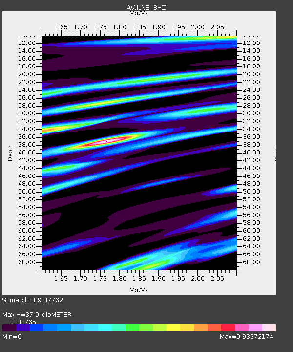
| Estimated Moho Depth: |
37.0 km |
| Estimated Crust Vp/Vs: |
1.76 |
| Assumed Crust Vp: |
6.566 km/s |
| Estimated Crust Vs: |
3.72 km/s |
| Estimated Crust Poisson's Ratio: |
0.26 |
|
| Radial Match: |
89.37762 % |
| Radial Bump: |
400 |
| Transverse Match: |
85.79214 % |
| Transverse Bump: |
400 |
| SOD ConfigId: |
34025071 |
| Insert Time: |
2024-04-17 00:09:13.224 +0000 |
| GWidth: |
2.5 |
| Max Bumps: |
400 |
| Tol: |
0.001 |
|

Signal To Noise
| Channel | StoN | STA | LTA |
| AV:ILNE: :BHZ:20240403T00:08:32.220004Z | 8.804001 | 2.3785121E-6 | 2.7016264E-7 |
| AV:ILNE: :BHN:20240403T00:08:32.220004Z | 6.232113 | 1.557775E-6 | 2.4995938E-7 |
| AV:ILNE: :BHE:20240403T00:08:32.220004Z | 5.3545694 | 1.3789269E-6 | 2.5752337E-7 |
| Arrivals |
| Ps | 4.5 SECOND |
| PpPs | 15 SECOND |
| PsPs/PpSs | 19 SECOND |


