You are here: Home > Network List > AV - Alaska Volcano Observatory Stations List
> Station KAWH Katmai, Alaska > Earthquake Result Viewer
KAWH Katmai, Alaska - Earthquake Result Viewer
| Earthquake location: |
Taiwan |
| Earthquake latitude/longitude: |
23.8/121.6 |
| Earthquake time(UTC): |
2024/04/02 (093) 23:58:11 GMT |
| Earthquake Depth: |
35 km |
| Earthquake Magnitude: |
7.4 mww |
| Earthquake Catalog/Contributor: |
NEIC PDE/us |
|
| Network: |
AV Alaska Volcano Observatory |
| Station: |
KAWH Katmai, Alaska |
| Lat/Lon: |
58.38 N/154.80 W |
| Elevation: |
777 m |
|
| Distance: |
66.7 deg |
| Az: |
34.739 deg |
| Baz: |
277.837 deg |
| Ray Param: |
0.05735787 |
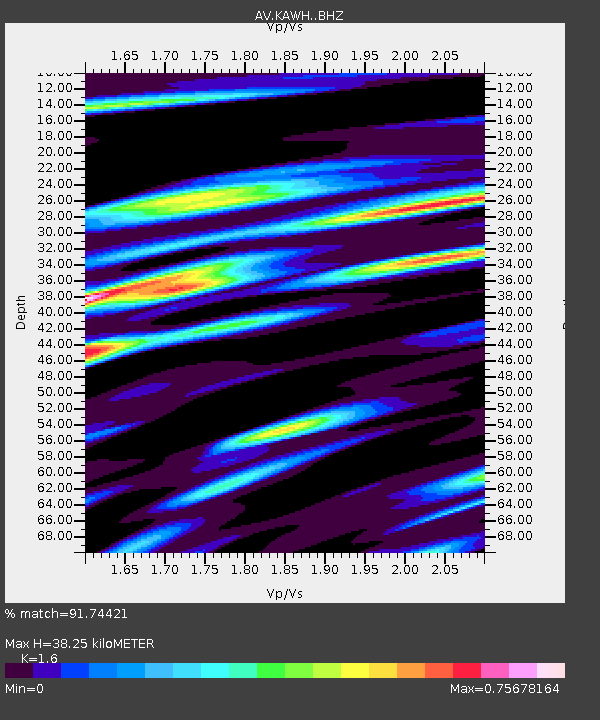
| Estimated Moho Depth: |
38.25 km |
| Estimated Crust Vp/Vs: |
1.60 |
| Assumed Crust Vp: |
6.438 km/s |
| Estimated Crust Vs: |
4.024 km/s |
| Estimated Crust Poisson's Ratio: |
0.18 |
|
| Radial Match: |
91.74421 % |
| Radial Bump: |
400 |
| Transverse Match: |
78.225685 % |
| Transverse Bump: |
400 |
| SOD ConfigId: |
34025071 |
| Insert Time: |
2024-04-17 00:09:30.470 +0000 |
| GWidth: |
2.5 |
| Max Bumps: |
400 |
| Tol: |
0.001 |
|

Signal To Noise
| Channel | StoN | STA | LTA |
| AV:KAWH: :BHZ:20240403T00:08:28.139987Z | 5.590363 | 2.013473E-6 | 3.6016857E-7 |
| AV:KAWH: :BHN:20240403T00:08:28.139987Z | 1.4921038 | 3.4615948E-7 | 2.3199424E-7 |
| AV:KAWH: :BHE:20240403T00:08:28.139987Z | 2.6015453 | 8.1877323E-7 | 3.1472572E-7 |
| Arrivals |
| Ps | 3.7 SECOND |
| PpPs | 15 SECOND |
| PsPs/PpSs | 18 SECOND |


