You are here: Home > Network List > TA - USArray Transportable Network (new EarthScope stations) Stations List
> Station SUSD Miller, SD, USA > Earthquake Result Viewer
SUSD Miller, SD, USA - Earthquake Result Viewer
| Earthquake location: |
Costa Rica |
| Earthquake latitude/longitude: |
10.2/-84.3 |
| Earthquake time(UTC): |
2010/10/09 (282) 01:54:04 GMT |
| Earthquake Depth: |
91 km |
| Earthquake Magnitude: |
5.5 MB, 5.8 MW, 5.8 MW |
| Earthquake Catalog/Contributor: |
WHDF/NEIC |
|
| Network: |
TA USArray Transportable Network (new EarthScope stations) |
| Station: |
SUSD Miller, SD, USA |
| Lat/Lon: |
44.44 N/98.96 W |
| Elevation: |
520 m |
|
| Distance: |
36.4 deg |
| Az: |
342.203 deg |
| Baz: |
155.164 deg |
| Ray Param: |
0.07642243 |
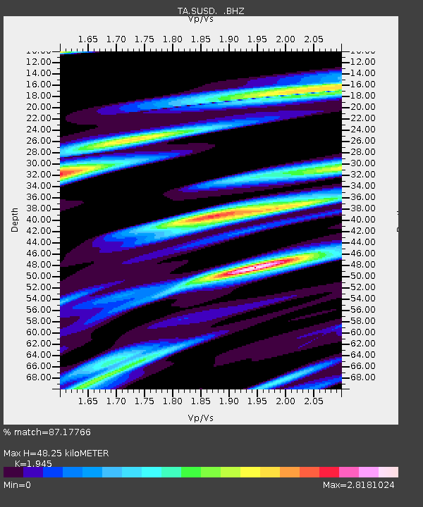
| Estimated Moho Depth: |
48.25 km |
| Estimated Crust Vp/Vs: |
1.95 |
| Assumed Crust Vp: |
6.53 km/s |
| Estimated Crust Vs: |
3.358 km/s |
| Estimated Crust Poisson's Ratio: |
0.32 |
|
| Radial Match: |
87.17766 % |
| Radial Bump: |
400 |
| Transverse Match: |
68.229576 % |
| Transverse Bump: |
366 |
| SOD ConfigId: |
339645 |
| Insert Time: |
2011-02-10 08:53:10.682 +0000 |
| GWidth: |
2.5 |
| Max Bumps: |
400 |
| Tol: |
0.001 |
|

Signal To Noise
| Channel | StoN | STA | LTA |
| TA:SUSD: :BHZ:20101009T02:00:29.774988Z | 4.4646072 | 5.7747616E-7 | 1.2934534E-7 |
| TA:SUSD: :BHN:20101009T02:00:29.774988Z | 2.533838 | 8.884723E-7 | 3.506429E-7 |
| TA:SUSD: :BHE:20101009T02:00:29.774988Z | 1.7629876 | 4.375342E-7 | 2.481777E-7 |
| Arrivals |
| Ps | 7.5 SECOND |
| PpPs | 20 SECOND |
| PsPs/PpSs | 28 SECOND |


