You are here: Home > Network List > AV - Alaska Volcano Observatory Stations List
> Station MNAT Nateekin Bay, Makushin Volcano, Alaska > Earthquake Result Viewer
MNAT Nateekin Bay, Makushin Volcano, Alaska - Earthquake Result Viewer
| Earthquake location: |
Taiwan |
| Earthquake latitude/longitude: |
23.8/121.6 |
| Earthquake time(UTC): |
2024/04/02 (093) 23:58:11 GMT |
| Earthquake Depth: |
35 km |
| Earthquake Magnitude: |
7.4 mww |
| Earthquake Catalog/Contributor: |
NEIC PDE/us |
|
| Network: |
AV Alaska Volcano Observatory |
| Station: |
MNAT Nateekin Bay, Makushin Volcano, Alaska |
| Lat/Lon: |
53.88 N/166.69 W |
| Elevation: |
390 m |
|
| Distance: |
60.4 deg |
| Az: |
40.272 deg |
| Baz: |
270.437 deg |
| Ray Param: |
0.061486144 |
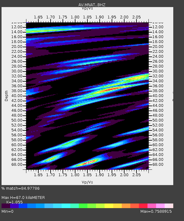
| Estimated Moho Depth: |
67.0 km |
| Estimated Crust Vp/Vs: |
1.86 |
| Assumed Crust Vp: |
3.943 km/s |
| Estimated Crust Vs: |
2.126 km/s |
| Estimated Crust Poisson's Ratio: |
0.30 |
|
| Radial Match: |
84.97786 % |
| Radial Bump: |
400 |
| Transverse Match: |
67.53421 % |
| Transverse Bump: |
400 |
| SOD ConfigId: |
34025071 |
| Insert Time: |
2024-04-17 00:09:50.847 +0000 |
| GWidth: |
2.5 |
| Max Bumps: |
400 |
| Tol: |
0.001 |
|

Signal To Noise
| Channel | StoN | STA | LTA |
| AV:MNAT: :BHZ:20240403T00:07:46.57999Z | 2.1847231 | 1.6273796E-6 | 7.4489054E-7 |
| AV:MNAT: :BHN:20240403T00:07:46.57999Z | 0.733053 | 6.72183E-7 | 9.1696364E-7 |
| AV:MNAT: :BHE:20240403T00:07:46.57999Z | 1.5512387 | 1.2825867E-6 | 8.268145E-7 |
| Arrivals |
| Ps | 15 SECOND |
| PpPs | 48 SECOND |
| PsPs/PpSs | 62 SECOND |


