You are here: Home > Network List > TA - USArray Transportable Network (new EarthScope stations) Stations List
> Station D33A AnnSam, Waubun, MN, USA > Earthquake Result Viewer
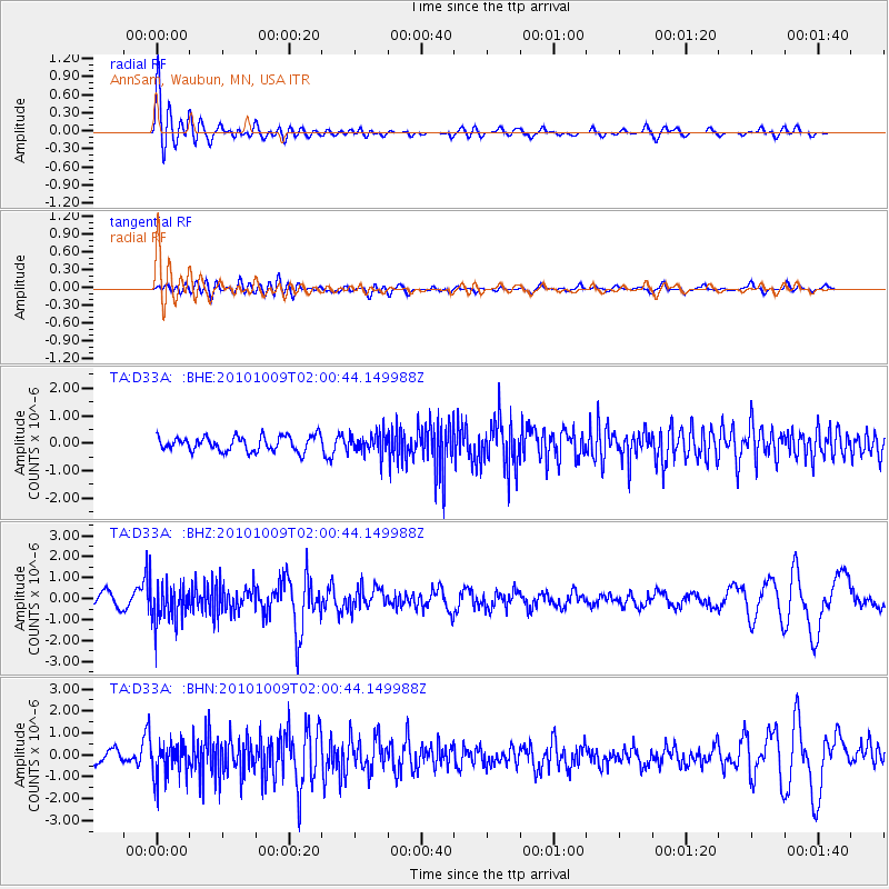
D33A AnnSam, Waubun, MN, USA - Earthquake Result Viewer
*The percent match for this event was below the threshold and hence no stack was calculated.
| Earthquake location: |
Costa Rica |
| Earthquake latitude/longitude: |
10.2/-84.3 |
| Earthquake time(UTC): |
2010/10/09 (282) 01:54:04 GMT |
| Earthquake Depth: |
91 km |
| Earthquake Magnitude: |
5.5 MB, 5.8 MW, 5.8 MW |
| Earthquake Catalog/Contributor: |
WHDF/NEIC |
|
| Network: |
TA USArray Transportable Network (new EarthScope stations) |
| Station: |
D33A AnnSam, Waubun, MN, USA |
| Lat/Lon: |
47.14 N/95.84 W |
| Elevation: |
466 m |
|
| Distance: |
38.1 deg |
| Az: |
347.196 deg |
| Baz: |
161.364 deg |
| Ray Param: |
$rayparam |
*The percent match for this event was below the threshold and hence was not used in the summary stack. |
|
| Radial Match: |
77.97648 % |
| Radial Bump: |
400 |
| Transverse Match: |
46.33028 % |
| Transverse Bump: |
400 |
| SOD ConfigId: |
339645 |
| Insert Time: |
2011-02-10 08:53:30.993 +0000 |
| GWidth: |
2.5 |
| Max Bumps: |
400 |
| Tol: |
0.001 |
|
Signal To Noise
| Channel | StoN | STA | LTA |
| TA:D33A: :BHZ:20101009T02:00:44.149988Z | 3.7818468 | 9.437839E-7 | 2.4955636E-7 |
| TA:D33A: :BHN:20101009T02:00:44.149988Z | 2.9823189 | 8.0259787E-7 | 2.6911871E-7 |
| TA:D33A: :BHE:20101009T02:00:44.149988Z | 1.3850977 | 3.727055E-7 | 2.6908245E-7 |
| Arrivals |
| Ps | |
| PpPs | |
| PsPs/PpSs | |


