You are here: Home > Network List > AV - Alaska Volcano Observatory Stations List
> Station R17L Mt. Peulik Volcano, AVO PLK4, AK, USA > Earthquake Result Viewer
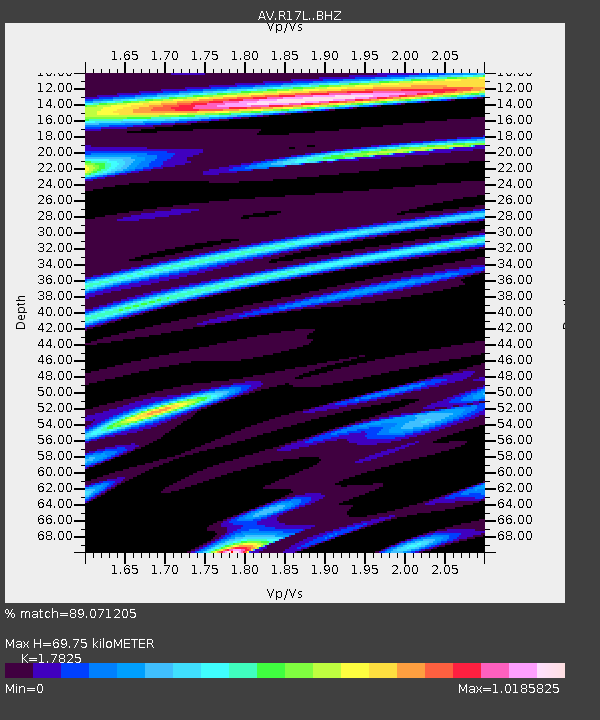
R17L Mt. Peulik Volcano, AVO PLK4, AK, USA - Earthquake Result Viewer
| Earthquake location: |
Taiwan |
| Earthquake latitude/longitude: |
23.8/121.6 |
| Earthquake time(UTC): |
2024/04/02 (093) 23:58:11 GMT |
| Earthquake Depth: |
35 km |
| Earthquake Magnitude: |
7.4 mww |
| Earthquake Catalog/Contributor: |
NEIC PDE/us |
|
| Network: |
AV Alaska Volcano Observatory |
| Station: |
R17L Mt. Peulik Volcano, AVO PLK4, AK, USA |
| Lat/Lon: |
57.63 N/156.36 W |
| Elevation: |
524 m |
|
| Distance: |
66.0 deg |
| Az: |
35.671 deg |
| Baz: |
276.891 deg |
| Ray Param: |
0.057837754 |
| Estimated Moho Depth: |
69.75 km |
| Estimated Crust Vp/Vs: |
1.78 |
| Assumed Crust Vp: |
6.1 km/s |
| Estimated Crust Vs: |
3.422 km/s |
| Estimated Crust Poisson's Ratio: |
0.27 |
|
| Radial Match: |
89.071205 % |
| Radial Bump: |
400 |
| Transverse Match: |
80.32708 % |
| Transverse Bump: |
400 |
| SOD ConfigId: |
34025071 |
| Insert Time: |
2024-04-17 00:10:20.199 +0000 |
| GWidth: |
2.5 |
| Max Bumps: |
400 |
| Tol: |
0.001 |
|

Signal To Noise
| Channel | StoN | STA | LTA |
| AV:R17L: :BHZ:20240403T00:08:23.499973Z | 2.903291 | 1.7276303E-6 | 5.950593E-7 |
| AV:R17L: :BHN:20240403T00:08:23.499973Z | 0.8227282 | 3.5920536E-7 | 4.366027E-7 |
| AV:R17L: :BHE:20240403T00:08:23.499973Z | 1.4284654 | 8.640096E-7 | 6.048516E-7 |
| Arrivals |
| Ps | 9.3 SECOND |
| PpPs | 31 SECOND |
| PsPs/PpSs | 40 SECOND |


