You are here: Home > Network List > TA - USArray Transportable Network (new EarthScope stations) Stations List
> Station D37A Cotton, MN, USA > Earthquake Result Viewer
D37A Cotton, MN, USA - Earthquake Result Viewer

| Earthquake location: |
Costa Rica |
| Earthquake latitude/longitude: |
10.2/-84.3 |
| Earthquake time(UTC): |
2010/10/09 (282) 01:54:04 GMT |
| Earthquake Depth: |
91 km |
| Earthquake Magnitude: |
5.5 MB, 5.8 MW, 5.8 MW |
| Earthquake Catalog/Contributor: |
WHDF/NEIC |
|
| Network: |
TA USArray Transportable Network (new EarthScope stations) |
| Station: |
D37A Cotton, MN, USA |
| Lat/Lon: |
47.16 N/92.43 W |
| Elevation: |
413 m |
|
| Distance: |
37.5 deg |
| Az: |
350.867 deg |
| Baz: |
166.764 deg |
| Ray Param: |
0.07582526 |
| Estimated Moho Depth: |
52.0 km |
| Estimated Crust Vp/Vs: |
1.73 |
| Assumed Crust Vp: |
6.571 km/s |
| Estimated Crust Vs: |
3.793 km/s |
| Estimated Crust Poisson's Ratio: |
0.25 |
|
| Radial Match: |
81.0563 % |
| Radial Bump: |
327 |
| Transverse Match: |
57.64287 % |
| Transverse Bump: |
400 |
| SOD ConfigId: |
339645 |
| Insert Time: |
2011-02-10 08:53:43.154 +0000 |
| GWidth: |
2.5 |
| Max Bumps: |
400 |
| Tol: |
0.001 |
|
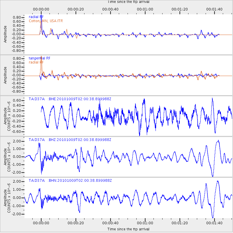
Signal To Noise
| Channel | StoN | STA | LTA |
| TA:D37A: :BHZ:20101009T02:00:38.899988Z | 3.1442804 | 8.483946E-7 | 2.6982156E-7 |
| TA:D37A: :BHN:20101009T02:00:38.899988Z | 2.3067393 | 5.558855E-7 | 2.4098324E-7 |
| TA:D37A: :BHE:20101009T02:00:38.899988Z | 0.78374565 | 2.1354423E-7 | 2.7246622E-7 |
| Arrivals |
| Ps | 6.3 SECOND |
| PpPs | 20 SECOND |
| PsPs/PpSs | 26 SECOND |


