You are here: Home > Network List > TA - USArray Transportable Network (new EarthScope stations) Stations List
> Station G32A Webster, SD, USA > Earthquake Result Viewer
G32A Webster, SD, USA - Earthquake Result Viewer
| Earthquake location: |
Costa Rica |
| Earthquake latitude/longitude: |
10.2/-84.3 |
| Earthquake time(UTC): |
2010/10/09 (282) 01:54:04 GMT |
| Earthquake Depth: |
91 km |
| Earthquake Magnitude: |
5.5 MB, 5.8 MW, 5.8 MW |
| Earthquake Catalog/Contributor: |
WHDF/NEIC |
|
| Network: |
TA USArray Transportable Network (new EarthScope stations) |
| Station: |
G32A Webster, SD, USA |
| Lat/Lon: |
45.26 N/97.50 W |
| Elevation: |
566 m |
|
| Distance: |
36.7 deg |
| Az: |
344.342 deg |
| Baz: |
157.906 deg |
| Ray Param: |
0.076242134 |
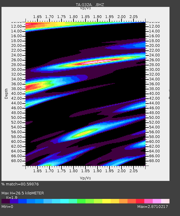
| Estimated Moho Depth: |
26.5 km |
| Estimated Crust Vp/Vs: |
1.90 |
| Assumed Crust Vp: |
6.552 km/s |
| Estimated Crust Vs: |
3.449 km/s |
| Estimated Crust Poisson's Ratio: |
0.31 |
|
| Radial Match: |
80.59876 % |
| Radial Bump: |
400 |
| Transverse Match: |
51.74116 % |
| Transverse Bump: |
390 |
| SOD ConfigId: |
339645 |
| Insert Time: |
2011-02-10 08:53:49.561 +0000 |
| GWidth: |
2.5 |
| Max Bumps: |
400 |
| Tol: |
0.001 |
|

Signal To Noise
| Channel | StoN | STA | LTA |
| TA:G32A: :BHZ:20101009T02:00:32.624994Z | 4.2823114 | 1.3696817E-6 | 3.1984638E-7 |
| TA:G32A: :BHN:20101009T02:00:32.624994Z | 1.6667883 | 1.5190747E-6 | 9.1137827E-7 |
| TA:G32A: :BHE:20101009T02:00:32.624994Z | 1.1817207 | 7.529198E-7 | 6.3713856E-7 |
| Arrivals |
| Ps | 3.9 SECOND |
| PpPs | 11 SECOND |
| PsPs/PpSs | 15 SECOND |


