You are here: Home > Network List > TA - USArray Transportable Network (new EarthScope stations) Stations List
> Station G36A St. Michael, MN, USA > Earthquake Result Viewer
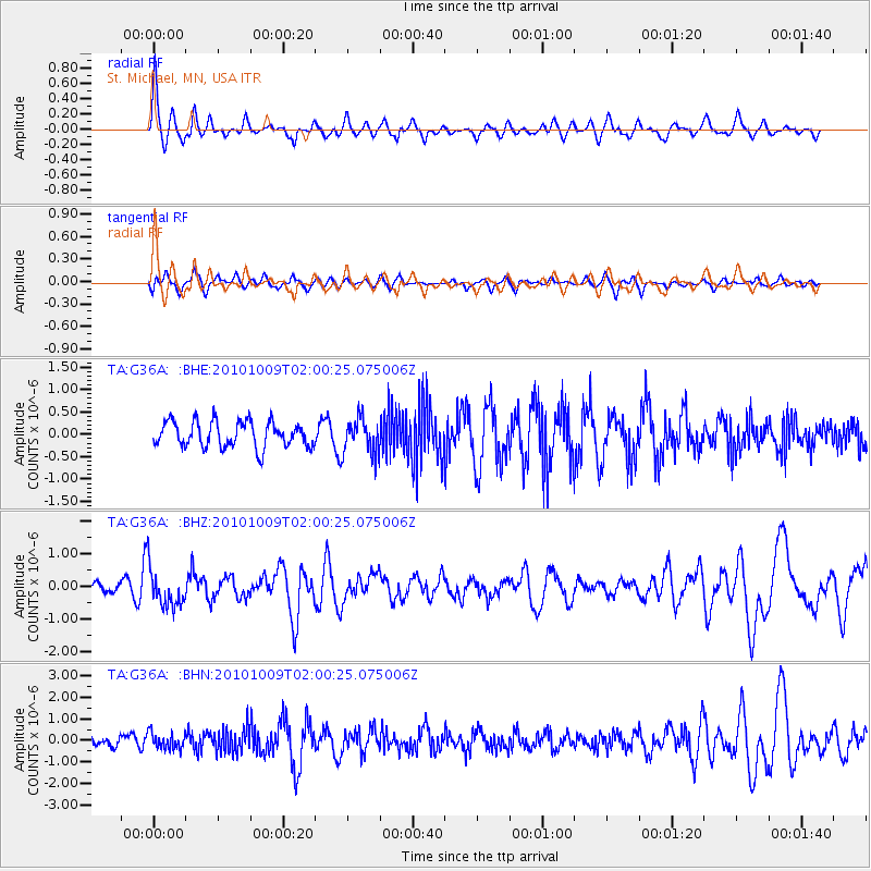
G36A St. Michael, MN, USA - Earthquake Result Viewer
*The percent match for this event was below the threshold and hence no stack was calculated.
| Earthquake location: |
Costa Rica |
| Earthquake latitude/longitude: |
10.2/-84.3 |
| Earthquake time(UTC): |
2010/10/09 (282) 01:54:04 GMT |
| Earthquake Depth: |
91 km |
| Earthquake Magnitude: |
5.5 MB, 5.8 MW, 5.8 MW |
| Earthquake Catalog/Contributor: |
WHDF/NEIC |
|
| Network: |
TA USArray Transportable Network (new EarthScope stations) |
| Station: |
G36A St. Michael, MN, USA |
| Lat/Lon: |
45.23 N/93.75 W |
| Elevation: |
293 m |
|
| Distance: |
35.8 deg |
| Az: |
348.561 deg |
| Baz: |
163.961 deg |
| Ray Param: |
$rayparam |
*The percent match for this event was below the threshold and hence was not used in the summary stack. |
|
| Radial Match: |
67.83159 % |
| Radial Bump: |
400 |
| Transverse Match: |
50.41601 % |
| Transverse Bump: |
400 |
| SOD ConfigId: |
339645 |
| Insert Time: |
2011-02-10 08:54:12.352 +0000 |
| GWidth: |
2.5 |
| Max Bumps: |
400 |
| Tol: |
0.001 |
|
Signal To Noise
| Channel | StoN | STA | LTA |
| TA:G36A: :BHZ:20101009T02:00:25.075006Z | 3.1054611 | 5.758754E-7 | 1.8543957E-7 |
| TA:G36A: :BHN:20101009T02:00:25.075006Z | 1.5645736 | 3.685488E-7 | 2.3555862E-7 |
| TA:G36A: :BHE:20101009T02:00:25.075006Z | 1.3656578 | 3.8850652E-7 | 2.8448306E-7 |
| Arrivals |
| Ps | |
| PpPs | |
| PsPs/PpSs | |


