You are here: Home > Network List > CC - Cascade Chain Volcano Monitoring Stations List
> Station CRBN Carbon River Ranger Station > Earthquake Result Viewer
CRBN Carbon River Ranger Station - Earthquake Result Viewer
| Earthquake location: |
Taiwan |
| Earthquake latitude/longitude: |
23.8/121.6 |
| Earthquake time(UTC): |
2024/04/02 (093) 23:58:11 GMT |
| Earthquake Depth: |
35 km |
| Earthquake Magnitude: |
7.4 mww |
| Earthquake Catalog/Contributor: |
NEIC PDE/us |
|
| Network: |
CC Cascade Chain Volcano Monitoring |
| Station: |
CRBN Carbon River Ranger Station |
| Lat/Lon: |
46.99 N/121.96 W |
| Elevation: |
500 m |
|
| Distance: |
89.2 deg |
| Az: |
37.795 deg |
| Baz: |
304.932 deg |
| Ray Param: |
0.041952122 |
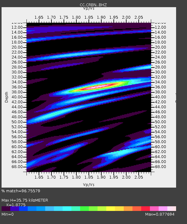
| Estimated Moho Depth: |
35.75 km |
| Estimated Crust Vp/Vs: |
1.88 |
| Assumed Crust Vp: |
6.597 km/s |
| Estimated Crust Vs: |
3.514 km/s |
| Estimated Crust Poisson's Ratio: |
0.30 |
|
| Radial Match: |
96.75579 % |
| Radial Bump: |
392 |
| Transverse Match: |
90.51397 % |
| Transverse Bump: |
400 |
| SOD ConfigId: |
34025071 |
| Insert Time: |
2024-04-17 00:12:30.166 +0000 |
| GWidth: |
2.5 |
| Max Bumps: |
400 |
| Tol: |
0.001 |
|

Signal To Noise
| Channel | StoN | STA | LTA |
| CC:CRBN: :BHZ:20240403T00:10:32.379978Z | 8.018675 | 1.6425015E-6 | 2.0483454E-7 |
| CC:CRBN: :BHN:20240403T00:10:32.379978Z | 3.5773787 | 2.786683E-7 | 7.789735E-8 |
| CC:CRBN: :BHE:20240403T00:10:32.379978Z | 1.584171 | 4.1782496E-7 | 2.637499E-7 |
| Arrivals |
| Ps | 4.9 SECOND |
| PpPs | 15 SECOND |
| PsPs/PpSs | 20 SECOND |


