You are here: Home > Network List > CN - Canadian National Seismograph Network Stations List
> Station FCC Fort Churchill, MB, CA > Earthquake Result Viewer
FCC Fort Churchill, MB, CA - Earthquake Result Viewer
| Earthquake location: |
Taiwan |
| Earthquake latitude/longitude: |
23.8/121.6 |
| Earthquake time(UTC): |
2024/04/02 (093) 23:58:11 GMT |
| Earthquake Depth: |
35 km |
| Earthquake Magnitude: |
7.4 mww |
| Earthquake Catalog/Contributor: |
NEIC PDE/us |
|
| Network: |
CN Canadian National Seismograph Network |
| Station: |
FCC Fort Churchill, MB, CA |
| Lat/Lon: |
58.76 N/94.09 W |
| Elevation: |
39 m |
|
| Distance: |
92.6 deg |
| Az: |
17.7 deg |
| Baz: |
327.704 deg |
| Ray Param: |
0.041422132 |
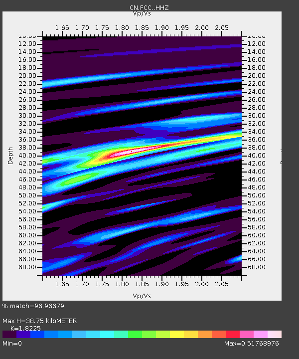
| Estimated Moho Depth: |
38.75 km |
| Estimated Crust Vp/Vs: |
1.82 |
| Assumed Crust Vp: |
6.455 km/s |
| Estimated Crust Vs: |
3.542 km/s |
| Estimated Crust Poisson's Ratio: |
0.28 |
|
| Radial Match: |
96.96679 % |
| Radial Bump: |
294 |
| Transverse Match: |
92.28959 % |
| Transverse Bump: |
400 |
| SOD ConfigId: |
34025071 |
| Insert Time: |
2024-04-17 00:14:52.752 +0000 |
| GWidth: |
2.5 |
| Max Bumps: |
400 |
| Tol: |
0.001 |
|

Signal To Noise
| Channel | StoN | STA | LTA |
| CN:FCC: :HHZ:20240403T00:10:47.82999Z | 13.356108 | 2.0157206E-6 | 1.5092127E-7 |
| CN:FCC: :HHN:20240403T00:10:47.82999Z | 4.102304 | 7.4713296E-7 | 1.821252E-7 |
| CN:FCC: :HHE:20240403T00:10:47.82999Z | 1.6080558 | 2.8236167E-7 | 1.7559195E-7 |
| Arrivals |
| Ps | 5.0 SECOND |
| PpPs | 17 SECOND |
| PsPs/PpSs | 22 SECOND |


