You are here: Home > Network List > PS - Pacific21 Stations List
> Station JAY Jayapura, Indonesia > Earthquake Result Viewer
JAY Jayapura, Indonesia - Earthquake Result Viewer
| Earthquake location: |
Taiwan |
| Earthquake latitude/longitude: |
23.8/121.6 |
| Earthquake time(UTC): |
2024/04/02 (093) 23:58:11 GMT |
| Earthquake Depth: |
35 km |
| Earthquake Magnitude: |
7.4 mww |
| Earthquake Catalog/Contributor: |
NEIC PDE/us |
|
| Network: |
PS Pacific21 |
| Station: |
JAY Jayapura, Indonesia |
| Lat/Lon: |
2.51 S/140.70 E |
| Elevation: |
439 m |
|
| Distance: |
32.1 deg |
| Az: |
141.976 deg |
| Baz: |
325.62 deg |
| Ray Param: |
0.07874616 |
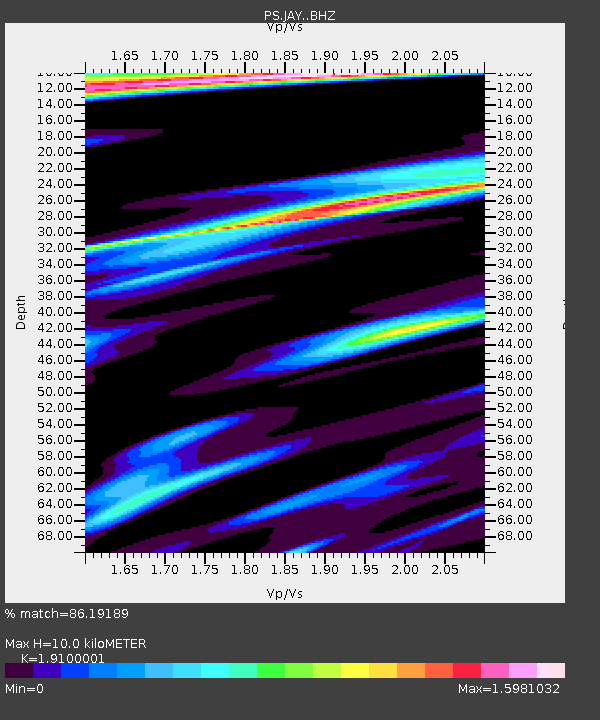
| Estimated Moho Depth: |
10.0 km |
| Estimated Crust Vp/Vs: |
1.91 |
| Assumed Crust Vp: |
6.461 km/s |
| Estimated Crust Vs: |
3.383 km/s |
| Estimated Crust Poisson's Ratio: |
0.31 |
|
| Radial Match: |
86.19189 % |
| Radial Bump: |
400 |
| Transverse Match: |
77.46844 % |
| Transverse Bump: |
400 |
| SOD ConfigId: |
34025071 |
| Insert Time: |
2024-04-17 00:23:42.067 +0000 |
| GWidth: |
2.5 |
| Max Bumps: |
400 |
| Tol: |
0.001 |
|

Signal To Noise
| Channel | StoN | STA | LTA |
| PS:JAY: :BHZ:20240403T00:04:05.110996Z | 12.579165 | 1.4078878E-6 | 1.1192219E-7 |
| PS:JAY: :BHN:20240403T00:04:05.110996Z | 7.6000686 | 7.265907E-7 | 9.5603184E-8 |
| PS:JAY: :BHE:20240403T00:04:05.110996Z | 5.255745 | 3.9652858E-7 | 7.544669E-8 |
| Arrivals |
| Ps | 1.5 SECOND |
| PpPs | 4.2 SECOND |
| PsPs/PpSs | 5.7 SECOND |


