You are here: Home > Network List > RC - BYU-Idaho Network (BYUI) Stations List
> Station CMI Centenial Mountain > Earthquake Result Viewer
CMI Centenial Mountain - Earthquake Result Viewer
| Earthquake location: |
Taiwan |
| Earthquake latitude/longitude: |
23.8/121.6 |
| Earthquake time(UTC): |
2024/04/02 (093) 23:58:11 GMT |
| Earthquake Depth: |
35 km |
| Earthquake Magnitude: |
7.4 mww |
| Earthquake Catalog/Contributor: |
NEIC PDE/us |
|
| Network: |
RC BYU-Idaho Network (BYUI) |
| Station: |
CMI Centenial Mountain |
| Lat/Lon: |
44.52 N/111.62 W |
| Elevation: |
2262 m |
|
| Distance: |
96.4 deg |
| Az: |
35.192 deg |
| Baz: |
312.458 deg |
| Ray Param: |
0.040500455 |
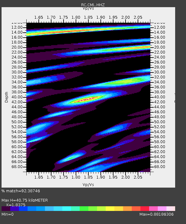
| Estimated Moho Depth: |
40.75 km |
| Estimated Crust Vp/Vs: |
1.84 |
| Assumed Crust Vp: |
6.35 km/s |
| Estimated Crust Vs: |
3.456 km/s |
| Estimated Crust Poisson's Ratio: |
0.29 |
|
| Radial Match: |
92.38746 % |
| Radial Bump: |
397 |
| Transverse Match: |
85.53891 % |
| Transverse Bump: |
400 |
| SOD ConfigId: |
34025071 |
| Insert Time: |
2024-04-17 00:24:05.595 +0000 |
| GWidth: |
2.5 |
| Max Bumps: |
400 |
| Tol: |
0.001 |
|

Signal To Noise
| Channel | StoN | STA | LTA |
| RC:CMI: :HHZ:20240403T00:11:05.32999Z | 2.6318362 | 4.92525E-7 | 1.8714121E-7 |
| RC:CMI: :HHN:20240403T00:11:05.32999Z | 1.0778362 | 1.7915623E-7 | 1.6621844E-7 |
| RC:CMI: :HHE:20240403T00:11:05.32999Z | 2.3942695 | 7.870528E-7 | 3.2872356E-7 |
| Arrivals |
| Ps | 5.5 SECOND |
| PpPs | 18 SECOND |
| PsPs/PpSs | 23 SECOND |


