You are here: Home > Network List > XG92 - Rocky Mountain Front Stations List
> Station DOT Dotsero, CO > Earthquake Result Viewer
DOT Dotsero, CO - Earthquake Result Viewer
| Earthquake location: |
Near Coast Of Nicaragua |
| Earthquake latitude/longitude: |
12.0/-87.3 |
| Earthquake time(UTC): |
1992/09/05 (249) 21:48:11 GMT |
| Earthquake Depth: |
10 km |
| Earthquake Magnitude: |
5.1 MB, 5.9 MS |
| Earthquake Catalog/Contributor: |
WHDF/NEIC |
|
| Network: |
XG Rocky Mountain Front |
| Station: |
DOT Dotsero, CO |
| Lat/Lon: |
39.78 N/106.99 W |
| Elevation: |
1982 m |
|
| Distance: |
32.7 deg |
| Az: |
331.335 deg |
| Baz: |
142.477 deg |
| Ray Param: |
0.078541 |
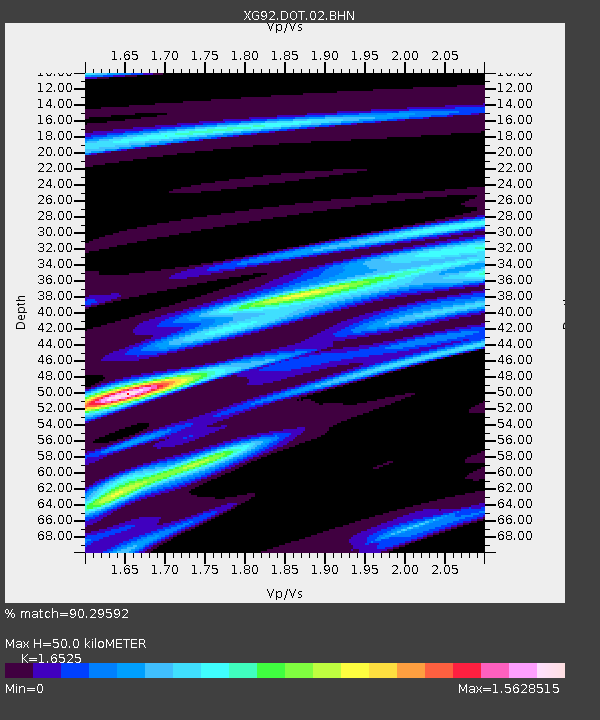
| Estimated Moho Depth: |
50.0 km |
| Estimated Crust Vp/Vs: |
1.65 |
| Assumed Crust Vp: |
6.306 km/s |
| Estimated Crust Vs: |
3.816 km/s |
| Estimated Crust Poisson's Ratio: |
0.21 |
|
| Radial Match: |
90.29592 % |
| Radial Bump: |
386 |
| Transverse Match: |
73.67539 % |
| Transverse Bump: |
400 |
| SOD ConfigId: |
3286 |
| Insert Time: |
2010-02-25 20:08:28.383 +0000 |
| GWidth: |
2.5 |
| Max Bumps: |
400 |
| Tol: |
0.001 |
|

Signal To Noise
| Channel | StoN | STA | LTA |
| XG:DOT:02:BHN:19920905T21:54:13.643011Z | 1.9756422 | 3.416181E-4 | 1.7291497E-4 |
| XG:DOT:02:BHE:19920905T21:54:13.643011Z | 3.7649236 | 3.5128585E-4 | 9.330491E-5 |
| XG:DOT:02:BHZ:19920905T21:54:13.643011Z | 6.154032 | 6.672852E-4 | 1.0843057E-4 |
| Arrivals |
| Ps | 5.6 SECOND |
| PpPs | 19 SECOND |
| PsPs/PpSs | 25 SECOND |


