You are here: Home > Network List > US - United States National Seismic Network Stations List
> Station MSO Missoula, Montana, USA > Earthquake Result Viewer
MSO Missoula, Montana, USA - Earthquake Result Viewer

| Earthquake location: |
Taiwan |
| Earthquake latitude/longitude: |
23.8/121.6 |
| Earthquake time(UTC): |
2024/04/02 (093) 23:58:11 GMT |
| Earthquake Depth: |
35 km |
| Earthquake Magnitude: |
7.4 mww |
| Earthquake Catalog/Contributor: |
NEIC PDE/us |
|
| Network: |
US United States National Seismic Network |
| Station: |
MSO Missoula, Montana, USA |
| Lat/Lon: |
46.83 N/113.94 W |
| Elevation: |
1264 m |
|
| Distance: |
93.7 deg |
| Az: |
34.544 deg |
| Baz: |
310.858 deg |
| Ray Param: |
0.041203327 |
| Estimated Moho Depth: |
47.0 km |
| Estimated Crust Vp/Vs: |
1.90 |
| Assumed Crust Vp: |
6.353 km/s |
| Estimated Crust Vs: |
3.348 km/s |
| Estimated Crust Poisson's Ratio: |
0.31 |
|
| Radial Match: |
92.61706 % |
| Radial Bump: |
400 |
| Transverse Match: |
89.33094 % |
| Transverse Bump: |
400 |
| SOD ConfigId: |
34025071 |
| Insert Time: |
2024-04-17 00:27:17.502 +0000 |
| GWidth: |
2.5 |
| Max Bumps: |
400 |
| Tol: |
0.001 |
|
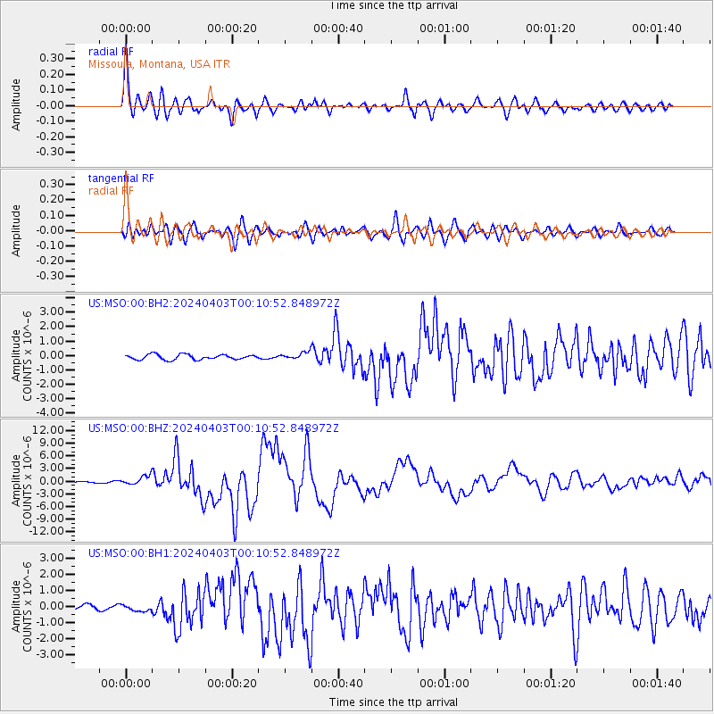
Signal To Noise
| Channel | StoN | STA | LTA |
| US:MSO:00:BHZ:20240403T00:10:52.848972Z | 8.007033 | 1.1034693E-6 | 1.3781249E-7 |
| US:MSO:00:BH1:20240403T00:10:52.848972Z | 1.9610889 | 2.0931734E-7 | 1.06735264E-7 |
| US:MSO:00:BH2:20240403T00:10:52.848972Z | 1.4412813 | 2.5215923E-7 | 1.7495489E-7 |
| Arrivals |
| Ps | 6.8 SECOND |
| PpPs | 21 SECOND |
| PsPs/PpSs | 28 SECOND |


