You are here: Home > Network List > UW - Pacific Northwest Regional Seismic Network Stations List
> Station DATON Dayton, WA, USA > Earthquake Result Viewer
DATON Dayton, WA, USA - Earthquake Result Viewer
| Earthquake location: |
Taiwan |
| Earthquake latitude/longitude: |
23.8/121.6 |
| Earthquake time(UTC): |
2024/04/02 (093) 23:58:11 GMT |
| Earthquake Depth: |
35 km |
| Earthquake Magnitude: |
7.4 mww |
| Earthquake Catalog/Contributor: |
NEIC PDE/us |
|
| Network: |
UW Pacific Northwest Regional Seismic Network |
| Station: |
DATON Dayton, WA, USA |
| Lat/Lon: |
46.26 N/117.93 W |
| Elevation: |
815 m |
|
| Distance: |
91.9 deg |
| Az: |
36.729 deg |
| Baz: |
307.867 deg |
| Ray Param: |
0.041533593 |
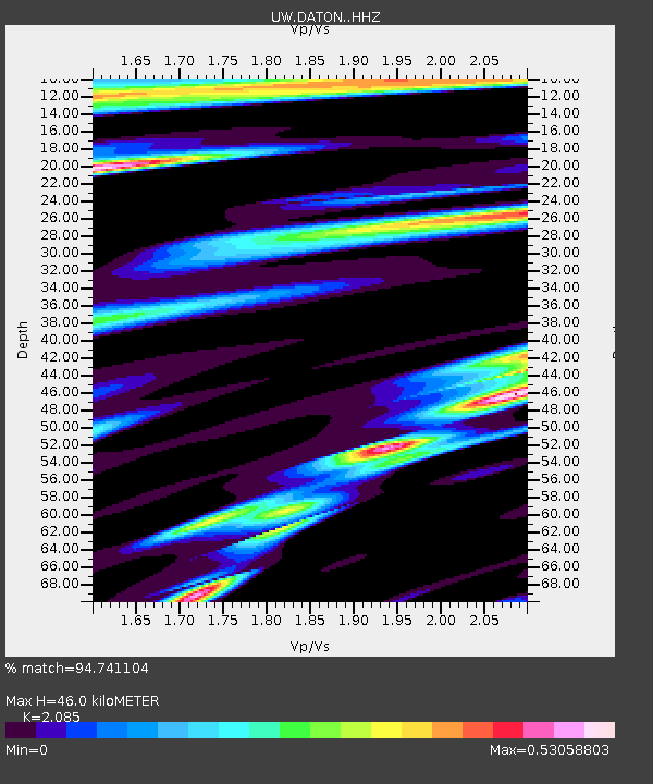
| Estimated Moho Depth: |
46.0 km |
| Estimated Crust Vp/Vs: |
2.09 |
| Assumed Crust Vp: |
6.571 km/s |
| Estimated Crust Vs: |
3.151 km/s |
| Estimated Crust Poisson's Ratio: |
0.35 |
|
| Radial Match: |
94.741104 % |
| Radial Bump: |
322 |
| Transverse Match: |
86.76326 % |
| Transverse Bump: |
400 |
| SOD ConfigId: |
34025071 |
| Insert Time: |
2024-04-17 00:28:16.902 +0000 |
| GWidth: |
2.5 |
| Max Bumps: |
400 |
| Tol: |
0.001 |
|

Signal To Noise
| Channel | StoN | STA | LTA |
| UW:DATON: :HHZ:20240403T00:10:44.720004Z | 4.693466 | 1.1845619E-6 | 2.5238532E-7 |
| UW:DATON: :HHN:20240403T00:10:44.720004Z | 1.5739205 | 2.5040083E-7 | 1.590937E-7 |
| UW:DATON: :HHE:20240403T00:10:44.720004Z | 2.346381 | 3.4945148E-7 | 1.4893213E-7 |
| Arrivals |
| Ps | 7.7 SECOND |
| PpPs | 21 SECOND |
| PsPs/PpSs | 29 SECOND |


