You are here: Home > Network List > UW - Pacific Northwest Regional Seismic Network Stations List
> Station GNW Green Mountain (BB) > Earthquake Result Viewer
GNW Green Mountain (BB) - Earthquake Result Viewer
| Earthquake location: |
Taiwan |
| Earthquake latitude/longitude: |
23.8/121.6 |
| Earthquake time(UTC): |
2024/04/02 (093) 23:58:11 GMT |
| Earthquake Depth: |
35 km |
| Earthquake Magnitude: |
7.4 mww |
| Earthquake Catalog/Contributor: |
NEIC PDE/us |
|
| Network: |
UW Pacific Northwest Regional Seismic Network |
| Station: |
GNW Green Mountain (BB) |
| Lat/Lon: |
47.56 N/122.83 W |
| Elevation: |
160 m |
|
| Distance: |
88.4 deg |
| Az: |
37.655 deg |
| Baz: |
304.296 deg |
| Ray Param: |
0.04254581 |
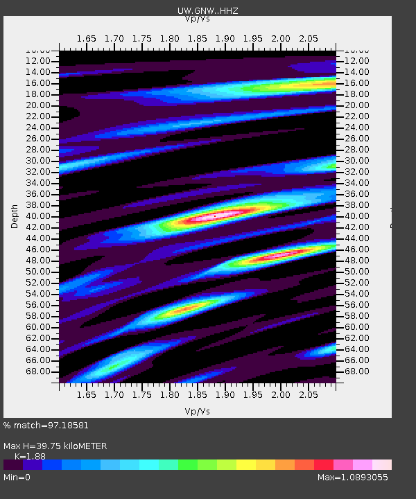
| Estimated Moho Depth: |
39.75 km |
| Estimated Crust Vp/Vs: |
1.88 |
| Assumed Crust Vp: |
6.566 km/s |
| Estimated Crust Vs: |
3.493 km/s |
| Estimated Crust Poisson's Ratio: |
0.30 |
|
| Radial Match: |
97.18581 % |
| Radial Bump: |
377 |
| Transverse Match: |
93.594986 % |
| Transverse Bump: |
346 |
| SOD ConfigId: |
34025071 |
| Insert Time: |
2024-04-17 00:28:42.964 +0000 |
| GWidth: |
2.5 |
| Max Bumps: |
400 |
| Tol: |
0.001 |
|
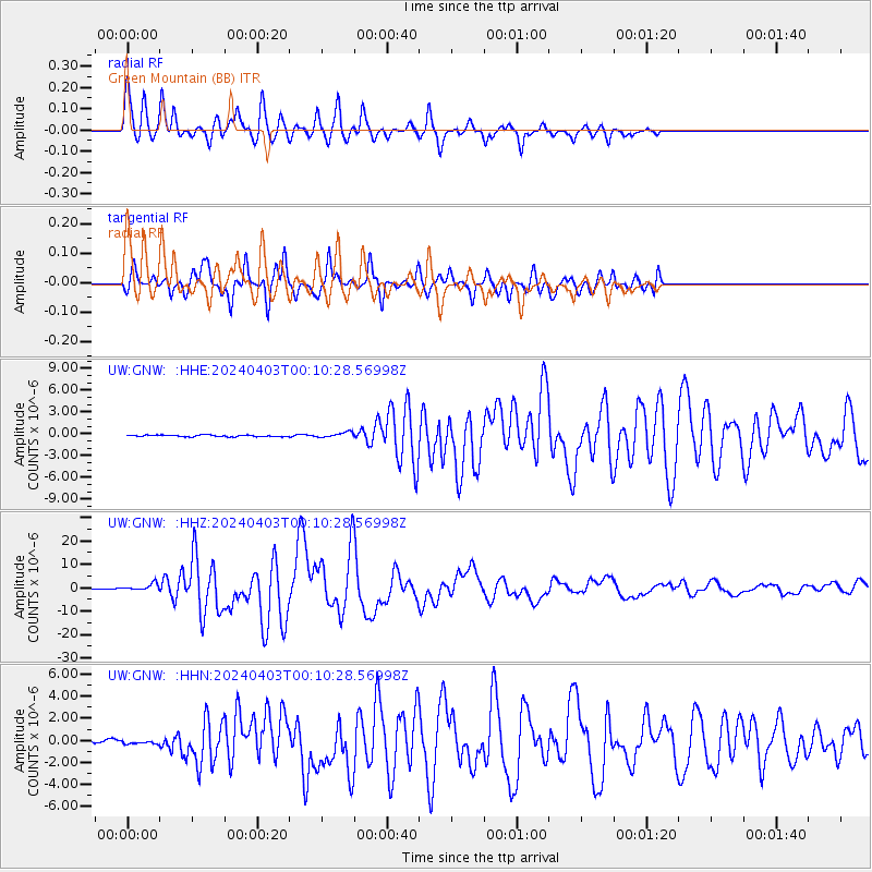
Signal To Noise
| Channel | StoN | STA | LTA |
| UW:GNW: :HHZ:20240403T00:10:28.56998Z | 10.489844 | 1.4886925E-6 | 1.419175E-7 |
| UW:GNW: :HHN:20240403T00:10:28.56998Z | 0.5264903 | 1.04963085E-7 | 1.9936377E-7 |
| UW:GNW: :HHE:20240403T00:10:28.56998Z | 3.16046 | 3.626363E-7 | 1.14741624E-7 |
| Arrivals |
| Ps | 5.4 SECOND |
| PpPs | 17 SECOND |
| PsPs/PpSs | 23 SECOND |


