You are here: Home > Network List > UW - Pacific Northwest Regional Seismic Network Stations List
> Station NEMA NEMA Site, Pacific County, WA, USA > Earthquake Result Viewer
NEMA NEMA Site, Pacific County, WA, USA - Earthquake Result Viewer
| Earthquake location: |
Taiwan |
| Earthquake latitude/longitude: |
23.8/121.6 |
| Earthquake time(UTC): |
2024/04/02 (093) 23:58:11 GMT |
| Earthquake Depth: |
35 km |
| Earthquake Magnitude: |
7.4 mww |
| Earthquake Catalog/Contributor: |
NEIC PDE/us |
|
| Network: |
UW Pacific Northwest Regional Seismic Network |
| Station: |
NEMA NEMA Site, Pacific County, WA, USA |
| Lat/Lon: |
46.50 N/123.75 W |
| Elevation: |
509 m |
|
| Distance: |
88.5 deg |
| Az: |
38.894 deg |
| Baz: |
303.655 deg |
| Ray Param: |
0.04249168 |
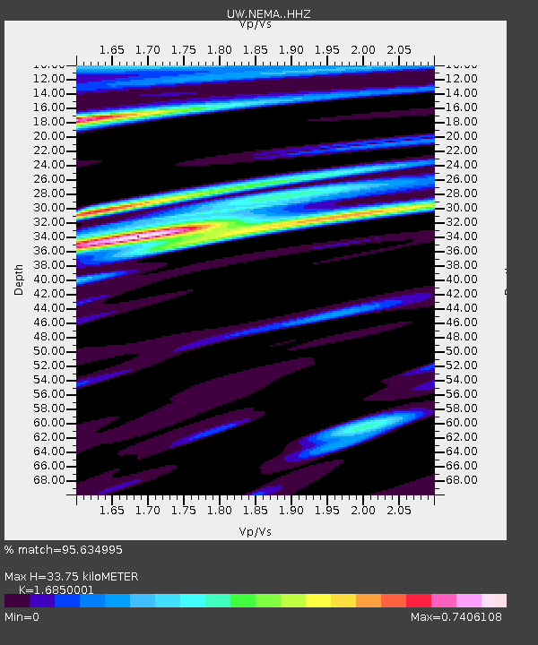
| Estimated Moho Depth: |
33.75 km |
| Estimated Crust Vp/Vs: |
1.69 |
| Assumed Crust Vp: |
6.566 km/s |
| Estimated Crust Vs: |
3.897 km/s |
| Estimated Crust Poisson's Ratio: |
0.23 |
|
| Radial Match: |
95.634995 % |
| Radial Bump: |
400 |
| Transverse Match: |
92.9138 % |
| Transverse Bump: |
400 |
| SOD ConfigId: |
34025071 |
| Insert Time: |
2024-04-17 00:29:45.759 +0000 |
| GWidth: |
2.5 |
| Max Bumps: |
400 |
| Tol: |
0.001 |
|

Signal To Noise
| Channel | StoN | STA | LTA |
| UW:NEMA: :HHZ:20240403T00:10:28.910007Z | 3.634531 | 1.3906048E-6 | 3.8260916E-7 |
| UW:NEMA: :HHN:20240403T00:10:28.910007Z | 0.6162087 | 3.611996E-7 | 5.8616445E-7 |
| UW:NEMA: :HHE:20240403T00:10:28.910007Z | 1.2073692 | 5.746817E-7 | 4.7597845E-7 |
| Arrivals |
| Ps | 3.6 SECOND |
| PpPs | 13 SECOND |
| PsPs/PpSs | 17 SECOND |


