You are here: Home > Network List > UW - Pacific Northwest Regional Seismic Network Stations List
> Station OLGA Olga, Orcas Island, WA, USA > Earthquake Result Viewer
OLGA Olga, Orcas Island, WA, USA - Earthquake Result Viewer
| Earthquake location: |
Taiwan |
| Earthquake latitude/longitude: |
23.8/121.6 |
| Earthquake time(UTC): |
2024/04/02 (093) 23:58:11 GMT |
| Earthquake Depth: |
35 km |
| Earthquake Magnitude: |
7.4 mww |
| Earthquake Catalog/Contributor: |
NEIC PDE/us |
|
| Network: |
UW Pacific Northwest Regional Seismic Network |
| Station: |
OLGA Olga, Orcas Island, WA, USA |
| Lat/Lon: |
48.60 N/122.80 W |
| Elevation: |
22 m |
|
| Distance: |
87.9 deg |
| Az: |
36.786 deg |
| Baz: |
304.284 deg |
| Ray Param: |
0.04297432 |
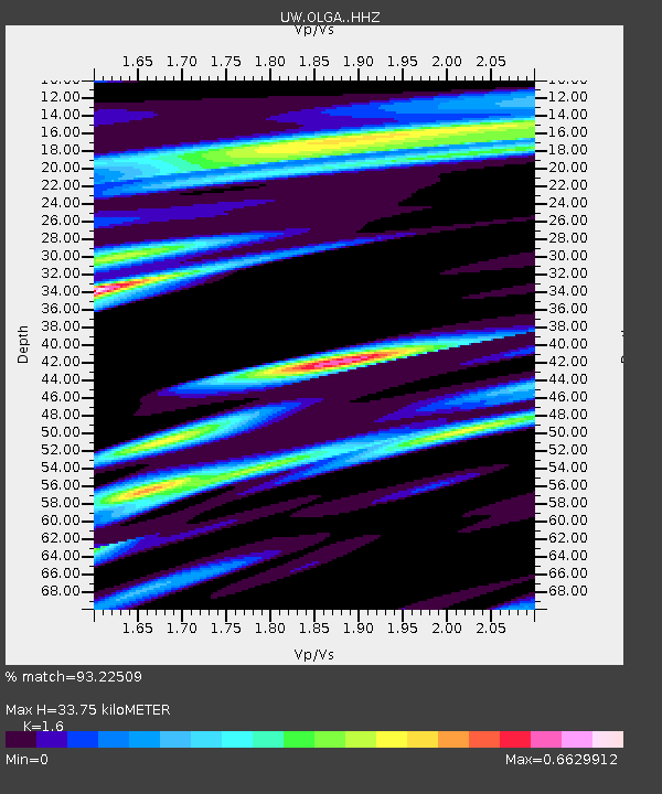
| Estimated Moho Depth: |
33.75 km |
| Estimated Crust Vp/Vs: |
1.60 |
| Assumed Crust Vp: |
6.566 km/s |
| Estimated Crust Vs: |
4.104 km/s |
| Estimated Crust Poisson's Ratio: |
0.18 |
|
| Radial Match: |
93.22509 % |
| Radial Bump: |
400 |
| Transverse Match: |
89.94401 % |
| Transverse Bump: |
400 |
| SOD ConfigId: |
34025071 |
| Insert Time: |
2024-04-17 00:29:52.043 +0000 |
| GWidth: |
2.5 |
| Max Bumps: |
400 |
| Tol: |
0.001 |
|

Signal To Noise
| Channel | StoN | STA | LTA |
| UW:OLGA: :HHZ:20240403T00:10:25.840Z | 5.612639 | 1.682236E-6 | 2.997228E-7 |
| UW:OLGA: :HHN:20240403T00:10:25.840Z | 1.7913035 | 3.4661053E-7 | 1.9349625E-7 |
| UW:OLGA: :HHE:20240403T00:10:25.840Z | 1.5976108 | 2.792124E-7 | 1.7476873E-7 |
| Arrivals |
| Ps | 3.2 SECOND |
| PpPs | 13 SECOND |
| PsPs/PpSs | 16 SECOND |


