You are here: Home > Network List > UW - Pacific Northwest Regional Seismic Network Stations List
> Station SEAS2 Gearhart, OR, USA > Earthquake Result Viewer
SEAS2 Gearhart, OR, USA - Earthquake Result Viewer
| Earthquake location: |
Taiwan |
| Earthquake latitude/longitude: |
23.8/121.6 |
| Earthquake time(UTC): |
2024/04/02 (093) 23:58:11 GMT |
| Earthquake Depth: |
35 km |
| Earthquake Magnitude: |
7.4 mww |
| Earthquake Catalog/Contributor: |
NEIC PDE/us |
|
| Network: |
UW Pacific Northwest Regional Seismic Network |
| Station: |
SEAS2 Gearhart, OR, USA |
| Lat/Lon: |
46.04 N/123.90 W |
| Elevation: |
59 m |
|
| Distance: |
88.7 deg |
| Az: |
39.335 deg |
| Baz: |
303.56 deg |
| Ray Param: |
0.042364255 |
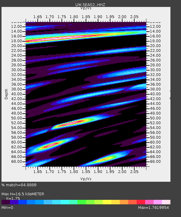
| Estimated Moho Depth: |
16.5 km |
| Estimated Crust Vp/Vs: |
1.75 |
| Assumed Crust Vp: |
6.566 km/s |
| Estimated Crust Vs: |
3.752 km/s |
| Estimated Crust Poisson's Ratio: |
0.26 |
|
| Radial Match: |
84.8889 % |
| Radial Bump: |
400 |
| Transverse Match: |
73.83942 % |
| Transverse Bump: |
400 |
| SOD ConfigId: |
34025071 |
| Insert Time: |
2024-04-17 00:30:26.427 +0000 |
| GWidth: |
2.5 |
| Max Bumps: |
400 |
| Tol: |
0.001 |
|

Signal To Noise
| Channel | StoN | STA | LTA |
| UW:SEAS2: :HHZ:20240403T00:10:29.720004Z | 2.0278888 | 1.7405947E-6 | 8.583285E-7 |
| UW:SEAS2: :HHN:20240403T00:10:29.720004Z | 1.3721546 | 1.3982974E-6 | 1.0190524E-6 |
| UW:SEAS2: :HHE:20240403T00:10:29.720004Z | 0.89628565 | 8.4885886E-7 | 9.470852E-7 |
| Arrivals |
| Ps | 1.9 SECOND |
| PpPs | 6.8 SECOND |
| PsPs/PpSs | 8.7 SECOND |


