You are here: Home > Network List > UW - Pacific Northwest Regional Seismic Network Stations List
> Station TNSKT Tonasket, WA, USA > Earthquake Result Viewer
TNSKT Tonasket, WA, USA - Earthquake Result Viewer
| Earthquake location: |
Taiwan |
| Earthquake latitude/longitude: |
23.8/121.6 |
| Earthquake time(UTC): |
2024/04/02 (093) 23:58:11 GMT |
| Earthquake Depth: |
35 km |
| Earthquake Magnitude: |
7.4 mww |
| Earthquake Catalog/Contributor: |
NEIC PDE/us |
|
| Network: |
UW Pacific Northwest Regional Seismic Network |
| Station: |
TNSKT Tonasket, WA, USA |
| Lat/Lon: |
48.72 N/119.44 W |
| Elevation: |
395 m |
|
| Distance: |
89.6 deg |
| Az: |
35.395 deg |
| Baz: |
306.77 deg |
| Ray Param: |
0.04173306 |
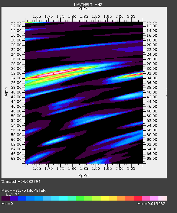
| Estimated Moho Depth: |
31.75 km |
| Estimated Crust Vp/Vs: |
1.72 |
| Assumed Crust Vp: |
6.419 km/s |
| Estimated Crust Vs: |
3.732 km/s |
| Estimated Crust Poisson's Ratio: |
0.24 |
|
| Radial Match: |
94.082794 % |
| Radial Bump: |
393 |
| Transverse Match: |
85.42315 % |
| Transverse Bump: |
400 |
| SOD ConfigId: |
34025071 |
| Insert Time: |
2024-04-17 00:30:49.155 +0000 |
| GWidth: |
2.5 |
| Max Bumps: |
400 |
| Tol: |
0.001 |
|

Signal To Noise
| Channel | StoN | STA | LTA |
| UW:TNSKT: :HHZ:20240403T00:10:34.050021Z | 10.351095 | 1.3099601E-6 | 1.265528E-7 |
| UW:TNSKT: :HHN:20240403T00:10:34.050021Z | 1.8781369 | 3.994762E-7 | 2.1269813E-7 |
| UW:TNSKT: :HHE:20240403T00:10:34.050021Z | 1.5085171 | 4.4621365E-7 | 2.9579618E-7 |
| Arrivals |
| Ps | 3.6 SECOND |
| PpPs | 13 SECOND |
| PsPs/PpSs | 17 SECOND |


