You are here: Home > Network List > WW - Idaho Seismic Network () Stations List
> Station BILL Emerald Creek, Idaho > Earthquake Result Viewer
BILL Emerald Creek, Idaho - Earthquake Result Viewer
| Earthquake location: |
Taiwan |
| Earthquake latitude/longitude: |
23.8/121.6 |
| Earthquake time(UTC): |
2024/04/02 (093) 23:58:11 GMT |
| Earthquake Depth: |
35 km |
| Earthquake Magnitude: |
7.4 mww |
| Earthquake Catalog/Contributor: |
NEIC PDE/us |
|
| Network: |
WW Idaho Seismic Network () |
| Station: |
BILL Emerald Creek, Idaho |
| Lat/Lon: |
47.03 N/116.34 W |
| Elevation: |
866 m |
|
| Distance: |
92.3 deg |
| Az: |
35.444 deg |
| Baz: |
309.065 deg |
| Ray Param: |
0.041473214 |
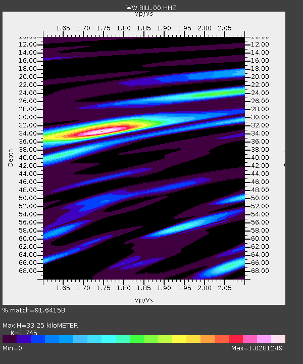
| Estimated Moho Depth: |
33.25 km |
| Estimated Crust Vp/Vs: |
1.75 |
| Assumed Crust Vp: |
6.571 km/s |
| Estimated Crust Vs: |
3.765 km/s |
| Estimated Crust Poisson's Ratio: |
0.26 |
|
| Radial Match: |
91.64158 % |
| Radial Bump: |
400 |
| Transverse Match: |
86.43265 % |
| Transverse Bump: |
400 |
| SOD ConfigId: |
34025071 |
| Insert Time: |
2024-04-17 00:31:47.665 +0000 |
| GWidth: |
2.5 |
| Max Bumps: |
400 |
| Tol: |
0.001 |
|

Signal To Noise
| Channel | StoN | STA | LTA |
| WW:BILL:00:HHZ:20240403T00:10:46.459995Z | 5.234813 | 8.6917356E-7 | 1.6603717E-7 |
| WW:BILL:00:HHN:20240403T00:10:46.459995Z | 2.8247979 | 4.833122E-7 | 1.710962E-7 |
| WW:BILL:00:HHE:20240403T00:10:46.459995Z | 2.2142906 | 4.894302E-7 | 2.2103251E-7 |
| Arrivals |
| Ps | 3.9 SECOND |
| PpPs | 14 SECOND |
| PsPs/PpSs | 17 SECOND |


