You are here: Home > Network List > AV - Alaska Volcano Observatory Stations List
> Station S12K Black Hills, AK, USA > Earthquake Result Viewer
S12K Black Hills, AK, USA - Earthquake Result Viewer
| Earthquake location: |
Taiwan |
| Earthquake latitude/longitude: |
24.1/121.7 |
| Earthquake time(UTC): |
2024/04/03 (094) 00:11:25 GMT |
| Earthquake Depth: |
13 km |
| Earthquake Magnitude: |
6.4 Mww |
| Earthquake Catalog/Contributor: |
NEIC PDE/us |
|
| Network: |
AV Alaska Volcano Observatory |
| Station: |
S12K Black Hills, AK, USA |
| Lat/Lon: |
55.70 N/162.06 W |
| Elevation: |
411 m |
|
| Distance: |
62.8 deg |
| Az: |
38.189 deg |
| Baz: |
273.264 deg |
| Ray Param: |
0.05998104 |
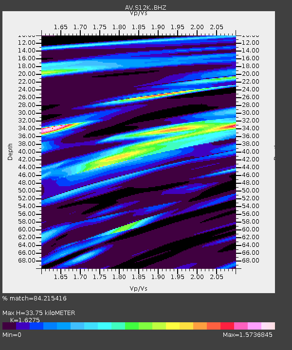
| Estimated Moho Depth: |
33.75 km |
| Estimated Crust Vp/Vs: |
1.63 |
| Assumed Crust Vp: |
5.989 km/s |
| Estimated Crust Vs: |
3.68 km/s |
| Estimated Crust Poisson's Ratio: |
0.20 |
|
| Radial Match: |
84.215416 % |
| Radial Bump: |
335 |
| Transverse Match: |
56.881096 % |
| Transverse Bump: |
400 |
| SOD ConfigId: |
34025071 |
| Insert Time: |
2024-04-17 00:37:26.134 +0000 |
| GWidth: |
2.5 |
| Max Bumps: |
400 |
| Tol: |
0.001 |
|

Signal To Noise
| Channel | StoN | STA | LTA |
| AV:S12K: :BHZ:20240403T00:21:19.35001Z | 1.8867083 | 1.0914993E-5 | 5.785205E-6 |
| AV:S12K: :BHN:20240403T00:21:19.35001Z | 1.487942 | 7.686783E-6 | 5.16605E-6 |
| AV:S12K: :BHE:20240403T00:21:19.35001Z | 1.8122365 | 1.4607764E-5 | 8.060628E-6 |
| Arrivals |
| Ps | 3.7 SECOND |
| PpPs | 14 SECOND |
| PsPs/PpSs | 18 SECOND |


