You are here: Home > Network List > TA - USArray Transportable Network (new EarthScope stations) Stations List
> Station 631A Perdido Creek Ranch, Del Rio, TX, USA > Earthquake Result Viewer
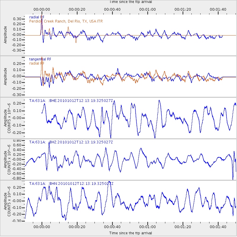
631A Perdido Creek Ranch, Del Rio, TX, USA - Earthquake Result Viewer
*The percent match for this event was below the threshold and hence no stack was calculated.
| Earthquake location: |
Tonga Islands |
| Earthquake latitude/longitude: |
-20.5/-174.2 |
| Earthquake time(UTC): |
2010/10/12 (285) 12:01:07 GMT |
| Earthquake Depth: |
10 km |
| Earthquake Magnitude: |
5.9 MB, 5.8 MS |
| Earthquake Catalog/Contributor: |
WHDF/NEIC |
|
| Network: |
TA USArray Transportable Network (new EarthScope stations) |
| Station: |
631A Perdido Creek Ranch, Del Rio, TX, USA |
| Lat/Lon: |
29.41 N/100.58 W |
| Elevation: |
344 m |
|
| Distance: |
86.5 deg |
| Az: |
57.002 deg |
| Baz: |
244.336 deg |
| Ray Param: |
$rayparam |
*The percent match for this event was below the threshold and hence was not used in the summary stack. |
|
| Radial Match: |
65.88941 % |
| Radial Bump: |
397 |
| Transverse Match: |
48.681995 % |
| Transverse Bump: |
273 |
| SOD ConfigId: |
339645 |
| Insert Time: |
2011-02-10 09:12:40.335 +0000 |
| GWidth: |
2.5 |
| Max Bumps: |
400 |
| Tol: |
0.001 |
|
Signal To Noise
| Channel | StoN | STA | LTA |
| TA:631A: :BHZ:20101012T12:13:19.325027Z | 3.263865 | 3.3326754E-7 | 1.0210825E-7 |
| TA:631A: :BHN:20101012T12:13:19.325027Z | 1.2317163 | 1.5906292E-7 | 1.2913925E-7 |
| TA:631A: :BHE:20101012T12:13:19.325027Z | 1.6652651 | 1.3670099E-7 | 8.2089635E-8 |
| Arrivals |
| Ps | |
| PpPs | |
| PsPs/PpSs | |


