You are here: Home > Network List > TA - USArray Transportable Network (new EarthScope stations) Stations List
> Station R30A Dighton, KS, USA > Earthquake Result Viewer
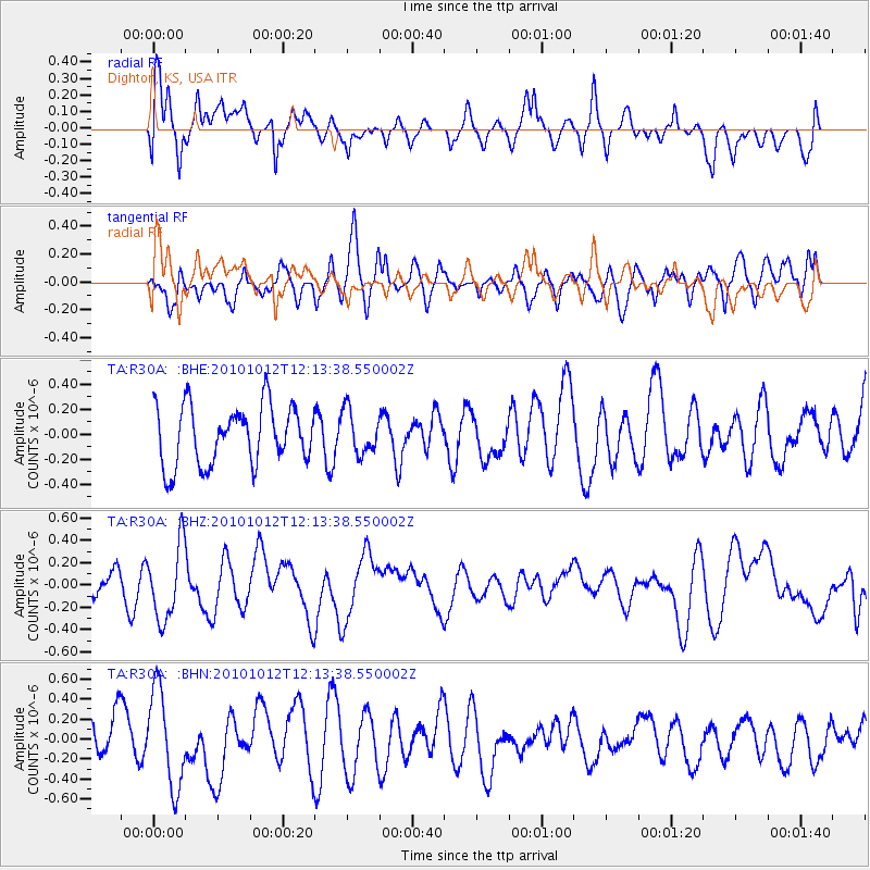
R30A Dighton, KS, USA - Earthquake Result Viewer
*The percent match for this event was below the threshold and hence no stack was calculated.
| Earthquake location: |
Tonga Islands |
| Earthquake latitude/longitude: |
-20.5/-174.2 |
| Earthquake time(UTC): |
2010/10/12 (285) 12:01:07 GMT |
| Earthquake Depth: |
10 km |
| Earthquake Magnitude: |
5.9 MB, 5.8 MS |
| Earthquake Catalog/Contributor: |
WHDF/NEIC |
|
| Network: |
TA USArray Transportable Network (new EarthScope stations) |
| Station: |
R30A Dighton, KS, USA |
| Lat/Lon: |
38.28 N/100.28 W |
| Elevation: |
776 m |
|
| Distance: |
90.6 deg |
| Az: |
49.134 deg |
| Baz: |
244.302 deg |
| Ray Param: |
$rayparam |
*The percent match for this event was below the threshold and hence was not used in the summary stack. |
|
| Radial Match: |
70.521 % |
| Radial Bump: |
400 |
| Transverse Match: |
59.200756 % |
| Transverse Bump: |
400 |
| SOD ConfigId: |
339645 |
| Insert Time: |
2011-02-10 09:13:08.858 +0000 |
| GWidth: |
2.5 |
| Max Bumps: |
400 |
| Tol: |
0.001 |
|
Signal To Noise
| Channel | StoN | STA | LTA |
| TA:R30A: :BHZ:20101012T12:13:38.550002Z | 2.1639862 | 3.3404623E-7 | 1.5436615E-7 |
| TA:R30A: :BHN:20101012T12:13:38.550002Z | 2.288545 | 4.837764E-7 | 2.113904E-7 |
| TA:R30A: :BHE:20101012T12:13:38.550002Z | 0.73700327 | 1.7262063E-7 | 2.3421961E-7 |
| Arrivals |
| Ps | |
| PpPs | |
| PsPs/PpSs | |


