You are here: Home > Network List > TA - USArray Transportable Network (new EarthScope stations) Stations List
> Station 434A Burnet, TX, USA > Earthquake Result Viewer
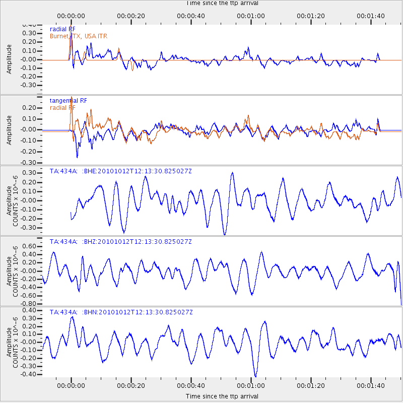
434A Burnet, TX, USA - Earthquake Result Viewer
*The percent match for this event was below the threshold and hence no stack was calculated.
| Earthquake location: |
Tonga Islands |
| Earthquake latitude/longitude: |
-20.5/-174.2 |
| Earthquake time(UTC): |
2010/10/12 (285) 12:01:07 GMT |
| Earthquake Depth: |
10 km |
| Earthquake Magnitude: |
5.9 MB, 5.8 MS |
| Earthquake Catalog/Contributor: |
WHDF/NEIC |
|
| Network: |
TA USArray Transportable Network (new EarthScope stations) |
| Station: |
434A Burnet, TX, USA |
| Lat/Lon: |
30.81 N/98.27 W |
| Elevation: |
462 m |
|
| Distance: |
88.9 deg |
| Az: |
56.585 deg |
| Baz: |
245.472 deg |
| Ray Param: |
$rayparam |
*The percent match for this event was below the threshold and hence was not used in the summary stack. |
|
| Radial Match: |
63.439884 % |
| Radial Bump: |
319 |
| Transverse Match: |
45.809055 % |
| Transverse Bump: |
370 |
| SOD ConfigId: |
339645 |
| Insert Time: |
2011-02-10 09:14:28.226 +0000 |
| GWidth: |
2.5 |
| Max Bumps: |
400 |
| Tol: |
0.001 |
|
Signal To Noise
| Channel | StoN | STA | LTA |
| TA:434A: :BHZ:20101012T12:13:30.825027Z | 1.3351306 | 2.4182867E-7 | 1.8112736E-7 |
| TA:434A: :BHN:20101012T12:13:30.825027Z | 1.8229151 | 2.0283191E-7 | 1.1126789E-7 |
| TA:434A: :BHE:20101012T12:13:30.825027Z | 0.44702092 | 6.5226835E-8 | 1.459145E-7 |
| Arrivals |
| Ps | |
| PpPs | |
| PsPs/PpSs | |


