You are here: Home > Network List > TA - USArray Transportable Network (new EarthScope stations) Stations List
> Station A04D Lummi Island, WA, USA > Earthquake Result Viewer
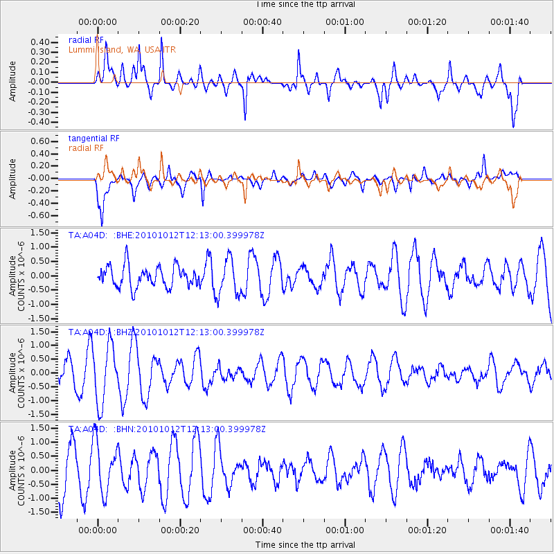
A04D Lummi Island, WA, USA - Earthquake Result Viewer
*The percent match for this event was below the threshold and hence no stack was calculated.
| Earthquake location: |
Tonga Islands |
| Earthquake latitude/longitude: |
-20.5/-174.2 |
| Earthquake time(UTC): |
2010/10/12 (285) 12:01:07 GMT |
| Earthquake Depth: |
10 km |
| Earthquake Magnitude: |
5.9 MB, 5.8 MS |
| Earthquake Catalog/Contributor: |
WHDF/NEIC |
|
| Network: |
TA USArray Transportable Network (new EarthScope stations) |
| Station: |
A04D Lummi Island, WA, USA |
| Lat/Lon: |
48.72 N/122.71 W |
| Elevation: |
13 m |
|
| Distance: |
82.7 deg |
| Az: |
31.496 deg |
| Baz: |
227.711 deg |
| Ray Param: |
$rayparam |
*The percent match for this event was below the threshold and hence was not used in the summary stack. |
|
| Radial Match: |
63.798313 % |
| Radial Bump: |
400 |
| Transverse Match: |
65.38551 % |
| Transverse Bump: |
400 |
| SOD ConfigId: |
339645 |
| Insert Time: |
2011-02-10 09:16:21.319 +0000 |
| GWidth: |
2.5 |
| Max Bumps: |
400 |
| Tol: |
0.001 |
|
Signal To Noise
| Channel | StoN | STA | LTA |
| TA:A04D: :BHZ:20101012T12:13:00.399978Z | 2.9367092 | 1.0651332E-6 | 3.626962E-7 |
| TA:A04D: :BHN:20101012T12:13:00.399978Z | 0.8361884 | 9.087573E-7 | 1.0867853E-6 |
| TA:A04D: :BHE:20101012T12:13:00.399978Z | 1.7346964 | 6.294819E-7 | 3.6287727E-7 |
| Arrivals |
| Ps | |
| PpPs | |
| PsPs/PpSs | |


