You are here: Home > Network List > US - United States National Seismic Network Stations List
> Station AMTX Amarillo, Texas, USA > Earthquake Result Viewer
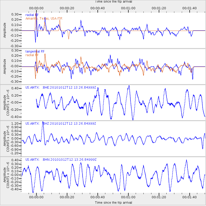
AMTX Amarillo, Texas, USA - Earthquake Result Viewer
*The percent match for this event was below the threshold and hence no stack was calculated.
| Earthquake location: |
Tonga Islands |
| Earthquake latitude/longitude: |
-20.5/-174.2 |
| Earthquake time(UTC): |
2010/10/12 (285) 12:01:07 GMT |
| Earthquake Depth: |
10 km |
| Earthquake Magnitude: |
5.9 MB, 5.8 MS |
| Earthquake Catalog/Contributor: |
WHDF/NEIC |
|
| Network: |
US United States National Seismic Network |
| Station: |
AMTX Amarillo, Texas, USA |
| Lat/Lon: |
34.53 N/101.41 W |
| Elevation: |
1010 m |
|
| Distance: |
88.1 deg |
| Az: |
52.101 deg |
| Baz: |
243.667 deg |
| Ray Param: |
$rayparam |
*The percent match for this event was below the threshold and hence was not used in the summary stack. |
|
| Radial Match: |
49.67311 % |
| Radial Bump: |
400 |
| Transverse Match: |
61.375423 % |
| Transverse Bump: |
400 |
| SOD ConfigId: |
339645 |
| Insert Time: |
2011-02-10 09:17:22.636 +0000 |
| GWidth: |
2.5 |
| Max Bumps: |
400 |
| Tol: |
0.001 |
|
Signal To Noise
| Channel | StoN | STA | LTA |
| US:AMTX: :BHZ:20101012T12:13:26.84999Z | 3.1164794 | 5.5326666E-7 | 1.7752937E-7 |
| US:AMTX: :BHN:20101012T12:13:26.84999Z | 1.8796164 | 2.5621426E-7 | 1.36312E-7 |
| US:AMTX: :BHE:20101012T12:13:26.84999Z | 1.3844976 | 1.7291259E-7 | 1.2489194E-7 |
| Arrivals |
| Ps | |
| PpPs | |
| PsPs/PpSs | |


