You are here: Home > Network List > TA - USArray Transportable Network (new EarthScope stations) Stations List
> Station X34A Smith Ranch, Marlow, OK, USA > Earthquake Result Viewer
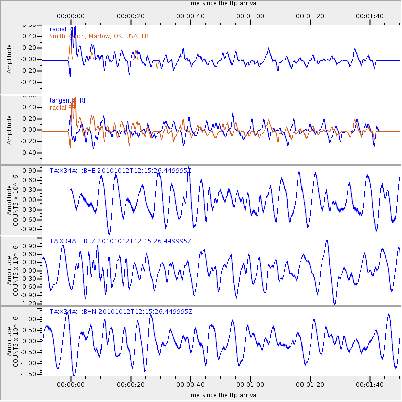
X34A Smith Ranch, Marlow, OK, USA - Earthquake Result Viewer
*The percent match for this event was below the threshold and hence no stack was calculated.
| Earthquake location: |
Tonga Islands |
| Earthquake latitude/longitude: |
-20.4/-174.1 |
| Earthquake time(UTC): |
2010/10/12 (285) 12:02:55 GMT |
| Earthquake Depth: |
12 km |
| Earthquake Magnitude: |
5.9 MB, 5.8 MS, 5.9 MW, 5.8 MW |
| Earthquake Catalog/Contributor: |
WHDF/NEIC |
|
| Network: |
TA USArray Transportable Network (new EarthScope stations) |
| Station: |
X34A Smith Ranch, Marlow, OK, USA |
| Lat/Lon: |
34.60 N/97.83 W |
| Elevation: |
364 m |
|
| Distance: |
90.7 deg |
| Az: |
53.251 deg |
| Baz: |
245.645 deg |
| Ray Param: |
$rayparam |
*The percent match for this event was below the threshold and hence was not used in the summary stack. |
|
| Radial Match: |
61.42946 % |
| Radial Bump: |
400 |
| Transverse Match: |
45.63311 % |
| Transverse Bump: |
400 |
| SOD ConfigId: |
339645 |
| Insert Time: |
2011-02-10 09:29:57.424 +0000 |
| GWidth: |
2.5 |
| Max Bumps: |
400 |
| Tol: |
0.001 |
|
Signal To Noise
| Channel | StoN | STA | LTA |
| TA:X34A: :BHZ:20101012T12:15:26.449995Z | 1.1742128 | 4.794684E-7 | 4.0833177E-7 |
| TA:X34A: :BHN:20101012T12:15:26.449995Z | 1.5227705 | 8.667867E-7 | 5.6921687E-7 |
| TA:X34A: :BHE:20101012T12:15:26.449995Z | 1.4668009 | 5.533516E-7 | 3.7725061E-7 |
| Arrivals |
| Ps | |
| PpPs | |
| PsPs/PpSs | |


