You are here: Home > Network List > TA - USArray Transportable Network (new EarthScope stations) Stations List
> Station 635A Leesville, TX, USA > Earthquake Result Viewer
635A Leesville, TX, USA - Earthquake Result Viewer
*The percent match for this event was below the threshold and hence no stack was calculated.
| Earthquake location: |
Tonga Islands |
| Earthquake latitude/longitude: |
-20.4/-174.1 |
| Earthquake time(UTC): |
2010/10/12 (285) 12:02:55 GMT |
| Earthquake Depth: |
12 km |
| Earthquake Magnitude: |
5.9 MB, 5.8 MS, 5.9 MW, 5.8 MW |
| Earthquake Catalog/Contributor: |
WHDF/NEIC |
|
| Network: |
TA USArray Transportable Network (new EarthScope stations) |
| Station: |
635A Leesville, TX, USA |
| Lat/Lon: |
29.39 N/97.77 W |
| Elevation: |
119 m |
|
| Distance: |
88.6 deg |
| Az: |
58.008 deg |
| Baz: |
245.707 deg |
| Ray Param: |
$rayparam |
*The percent match for this event was below the threshold and hence was not used in the summary stack. |
|
| Radial Match: |
46.521652 % |
| Radial Bump: |
400 |
| Transverse Match: |
47.887455 % |
| Transverse Bump: |
400 |
| SOD ConfigId: |
339645 |
| Insert Time: |
2011-02-10 09:31:05.399 +0000 |
| GWidth: |
2.5 |
| Max Bumps: |
400 |
| Tol: |
0.001 |
|
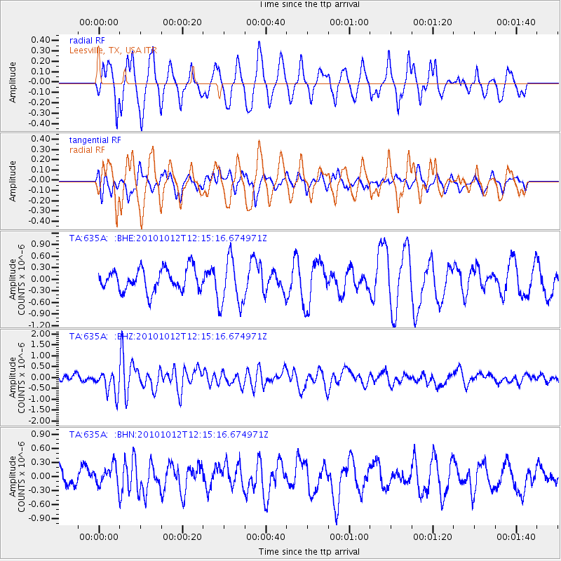
Signal To Noise
| Channel | StoN | STA | LTA |
| TA:635A: :BHZ:20101012T12:15:16.674971Z | 3.4311125 | 5.414701E-7 | 1.5781183E-7 |
| TA:635A: :BHN:20101012T12:15:16.674971Z | 1.1960692 | 2.2060141E-7 | 1.8443866E-7 |
| TA:635A: :BHE:20101012T12:15:16.674971Z | 2.1896915 | 6.2288547E-7 | 2.8446266E-7 |
| Arrivals |
| Ps | |
| PpPs | |
| PsPs/PpSs | |


