You are here: Home > Network List > TA - USArray Transportable Network (new EarthScope stations) Stations List
> Station H31A Wolsey, SD, USA > Earthquake Result Viewer
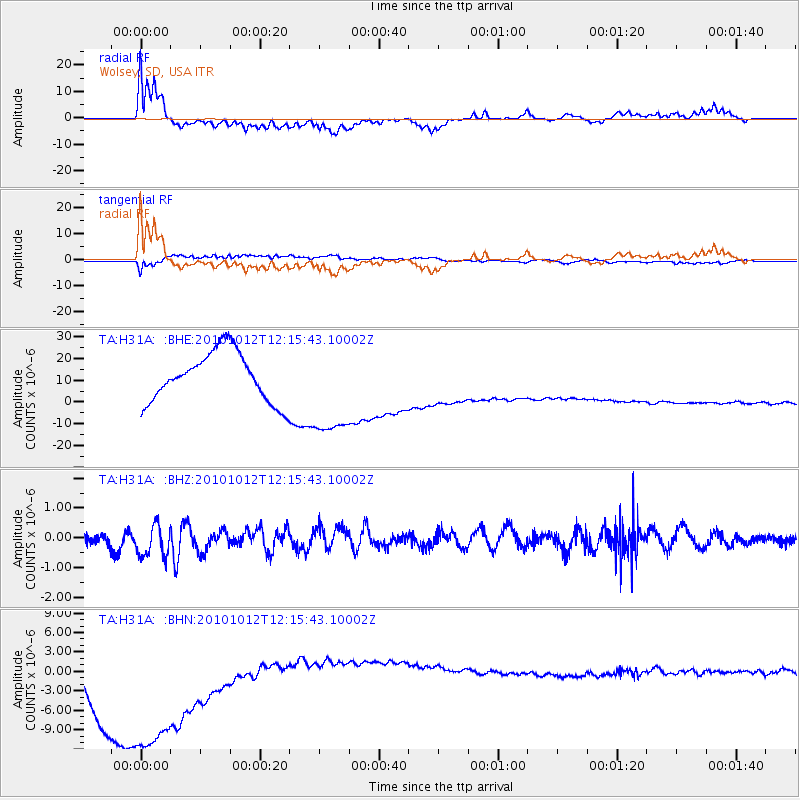
H31A Wolsey, SD, USA - Earthquake Result Viewer
*The percent match for this event was below the threshold and hence no stack was calculated.
| Earthquake location: |
Tonga Islands |
| Earthquake latitude/longitude: |
-20.4/-174.1 |
| Earthquake time(UTC): |
2010/10/12 (285) 12:02:55 GMT |
| Earthquake Depth: |
12 km |
| Earthquake Magnitude: |
5.9 MB, 5.8 MS, 5.9 MW, 5.8 MW |
| Earthquake Catalog/Contributor: |
WHDF/NEIC |
|
| Network: |
TA USArray Transportable Network (new EarthScope stations) |
| Station: |
H31A Wolsey, SD, USA |
| Lat/Lon: |
44.48 N/98.48 W |
| Elevation: |
415 m |
|
| Distance: |
94.3 deg |
| Az: |
44.05 deg |
| Baz: |
245.637 deg |
| Ray Param: |
$rayparam |
*The percent match for this event was below the threshold and hence was not used in the summary stack. |
|
| Radial Match: |
50.85706 % |
| Radial Bump: |
400 |
| Transverse Match: |
27.670103 % |
| Transverse Bump: |
394 |
| SOD ConfigId: |
339645 |
| Insert Time: |
2011-02-10 09:32:35.455 +0000 |
| GWidth: |
2.5 |
| Max Bumps: |
400 |
| Tol: |
0.001 |
|
Signal To Noise
| Channel | StoN | STA | LTA |
| TA:H31A: :BHZ:20101012T12:15:43.10002Z | 0.95015395 | 5.805497E-7 | 6.110059E-7 |
| TA:H31A: :BHN:20101012T12:15:43.10002Z | 1.9647193 | 2.2202606E-5 | 1.1300651E-5 |
| TA:H31A: :BHE:20101012T12:15:43.10002Z | 2.0506191 | 2.3145501E-5 | 1.1287079E-5 |
| Arrivals |
| Ps | |
| PpPs | |
| PsPs/PpSs | |


